
Several years ago (more then one, less then ten thousand) the idea that the Earth was not the center of the Universe was high in the ranks of things we argued about. Neatly behind that would be the age of the Universe, age of the Earth, the Earth goes around the sun, Earth is flat, etc. In time, a number of these ideas were accepted by pretty much everyone. By that I mean that I doubt even YEC will argue the point that the Earth is the center of the Universe and in addition to being flat also has the sun and everything else revolve around it.
On that line of thinking, I'd like to ask what you think of plate tectonics in that regard. It isn't brought up much on these boards, but because it neatly explains how we get fossils and strata on opposite sides of the Ocean all neatly lined up (such as the shore between Africa and South America), I imagine there must be some controversy surrounding it.
So, plate tectonics, is it like the Earth being round, or closer to evolution in terms of the amount of public debate surrounding it?
Plate Techtonics!
Moderator: Moderators
Plate Techtonics!
Post #1"Secular schools can never be tolerated because such schools have no religious instruction, and a general moral instruction without a religious foundation is built on air...we need believing people."
[Adolf Hitler, April 26, 1933]
[Adolf Hitler, April 26, 1933]
Post #71
Hi otseng,otseng wrote:What do you mean by "crash"? The plates have already "crashed". That is, all plates have always abutted next to each other. It is not like if the plates are giant pieces of wood floating on top of a large pool of water. All the plates are adjoining to one another. If one plate moves, it already "crashes" into another. So, another question, why do we not see this evidence of "crashing"?
There’ve been a lot of posts since I last visited this site, this is definitely a lively topic. In order to break this thread up into manageable bites for me I’m going to stick to a single topic for now - mountain building.
I brought this up in the Q’s for U’s thread (http://www.debatingchristianity.com/for ... 6&start=30). Here’s what I posted:
Let me summarize: In the case of the Grenville Orogeny deformed Precambrian rocks are overlain by undeformed Paleozoic rocks. In the case of the Antler Orogeny deformed Paleozoic and Precambrian rocks are overlain by undeformed Mesozoic and Cenozoic rocks. Why isn’t this acceptable to you as evidence that the Grenville Orogeny happened in the Precambrian and the Antler Orogeny happened in the Mesozoic? Why aren’t these examples of what you said you’d expect to see in the rock record if conventional geology is correct?This is what is seen in the rock record. I mentioned several different orogenies (mountain building events). I’ll use two of them, the Late Precambrian Grenville orogeny and the Early Paleozoic Antler orogeny as examples.
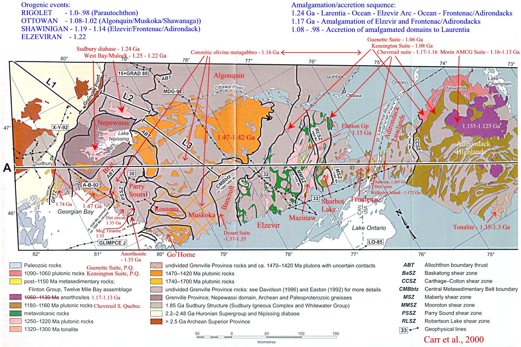
Grenville Orogeny
Someone at the University of Western Ontario maintains a website with a glut of information about the Grenville Orogeny. They scanned a geologic map of the Grenville in part of eastern North America that can be found here:
http://instruct.uwo.ca/earth-sci/300b-0 ... ap1800.jpg
All of the features on that map that have labels that end in “SZ” are shear zones (the key for the shear zones is at the bottom right of the image). You can see that none of these shear zones cut the overlying Paleozoic cover (the blue formation). This means that all of those shear zones became inactive before the Paleozoic cover was deposited, and so are pre-Paleozoic (Precambrian in other words) in age.
Antler Orogeny
I tried to find detailed geologic maps of rocks deformed during the Antler Orogeny that are available online, but I didn’t have much luck. I’ve found a generalized geologic map here:
http://www.nsm.buffalo.edu/courses/gly4 ... ntler2.pdf
Go to page 2 of the document. The left column is titled “Roberts Mountain (sic) Allochthon” There’s a linear feature on the map that’s labeled RMT, which stands for Roberts Mountains Thrust, one of the major faults that formed during the Antler Orogeny. You can get a rough idea about the age of that fault from this map. If you follow it north just about to the border of Nevada and Idaho you’ll see that the fault is truncated by a features labeled “Cenozoic cover.” Since the fault doesn’t offset this formation those rocks were deposited after the fault became inactive, and therefore the fault is pre-Cenozoic.
If you follow the fault to the south you’ll see that it’s truncated by a group of rocks labeled “Mesozoic plutons.” Since these rocks aren’t cut by the fault the Roberts Mountains thrust is pre-Mesozoic.
This isn’t shown on the map since it’s too generalized, but the fault cuts Early Paleozoic rocks, and so it’s older than that times. By looking at the age of the oldest formation that is not offset by the fault, as well as the age of sediments eroded from the fault when it was active, the Roberts Mountains thrust became inactive in Early Mississippian time.
Papers that discuss the timing of the Antler Orogeny:
There’s not much in the abstract of the first paper, but they have a section of their paper titled “General geology of the Antler orogen” that’s useful.
Burchfiel, B. C., and Royden, L. H. 1991. Antler Orogeny – A Mediterranean-type orogeny. Geology 19, 66-69.
Abstract: http://www.gsajournals.org/gsaonline/?r ... 2.3.CO%3B2
Johnson, J. G., and Pendergast, A., 1981. Timing and mode of emplacement of the Roberts Mountains allochthon, Antler Orogeny. Geological Society of America Bulletin 92, 648-658.
Abstract: http://www.gsajournals.org/gsaonline/?r ... 2.0.CO%3B2
Post #72
The young earth creationist claim that thrust faults don't exist dates back almost a century. This claim was first made in the early years of the 20th century by George Macready Price, who inspired Henry Morris, founder of the ICR and the modern YEC movement.YEC wrote:John S,
is anyone denying that thrust don't occur? Perhaps you are.
Links to young earth organizations denying the existence of thrust faults are common. From http://www.talkorigins.org/faqs/lewis/
YEC links about the Lewis thrust
The Problem of Geological Overthrusts at pathlights.com
http://www.pathlights.com/ce_encyclopedia/12fos10.htm
The Lewis Overthrust by Clifford L. Burdick (scroll down)
http://www.creationresearch.org/crsq/ab ... um6_2.html
The Lewis Overthrust Fiasco at godspointofview.com (scroll down)
http://www.godspointofview.com/public/a ... flood.html
Do All Fossils Appear in the Approved Evolutionary Order? by The Creation Explanation
http://www.parentcompany.com/creation_e ... n/cx3g.htm
A Decade of Creationist Research by Duane T. Gish
http://www.db.informatik.uni-kassel.de/ ... 2_1a1.html
NOTE: This is a dead link. A working link is here:
http://www.creationresearch.org/crsq/ar ... 2_1a1.html
Northrup's Biblical Nuggets: The Death of the Dinosaurs by Bernard E. Northrup
http://northrup.awwwsome.com/DEATH%20OF ... SAURS.html
Among other mistakes, Northrup states the Lewis thrust is Proterozoic. Northrup's multiple catastrophe model is addressed by Joe Meert at this link:
Can Creationists Fit the Flood in a Geologic Framework
http://baby.indstate.edu/gga/pmag/northrup.htm
NOTE: The link to Northrup's site is dead and I cannot find a working link.
Historical Geology and "Fault Finding" by Douglas B. Sharp (scroll down)
http://www.rae.org/revev2.html
NOTE: Sharp presents a simplified cross section through the Lewis thrust on his page. The bedding in the Cretaceous shales under the Lewis thrust is drawn at an angle to the fault and overlying beds, and yet in the text preceding his figure Sharp claims "The contact line between the two different strata is like a knife edge, suggesting that instead of an overthrust, the strata were water deposited in that order."
Jose has already addressed this. I thank him for highlighting the public portions of the articles I linked to.YEC wrote: Your failuure, especially the links you presented really don't talk of the subject. If they actually do it would have been nice if you quoted from that portion of the text so it could easily be found...but as I said, i looked and found nothing about folding rocks.
From your post of March 25 (emphasis added):YEC wrote: It talked about thrust..so what?
You imply that conventional geologists attribute mountains to purely vertical uplift. As I said before, the fact that geologists have recognized thrust faults with horizontal offsets of 10's of miles (in other words 10's of miles of horizontal motion), quite clearly shows your claim to be false.YEC wrote: Figure 47: Buckled Mountains. Textbooks and museums frequently refer to some uplifting force that formed mountains. Can you see that an uplifting force, by itself, could not cause this pattern? Horizontal compression was needed to buckle these sedimentary layers near the Sullivan River in southern British Columbia, Canada.

Post #73
Pardon me, but after reading all the posts in this thread isn't it safe to say that GPS data conclusively shows plate tectonics in action? After all, this was the subject of Nyrils poll. GPS has been around long enough and the continental drift is large enough to make the supporting data freely available.
Post #74
GPS and other geodetic measurements are certainly important since, as you put it, they show plate motions in action. However, GPS isn't the end of the story. What GPS doesn't help with is past plate motions, but that's where geology comes in (for example, the study of mountain belts, which mark areas of past or present plate collisions). GPS is just once piece in a very large set of geologic and geodetic lines of evidence that comprise the theory of plate tectonics, but it's not the be all and end all.QED wrote:Pardon me, but after reading all the posts in this thread isn't it safe to say that GPS data conclusively shows plate tectonics in action? After all, this was the subject of Nyrils poll. GPS has been around long enough and the continental drift is large enough to make the supporting data freely available.
If you want to see one of the most ambitious research programs that will use GPS to measure plate motion you should check out the Plate Boundary Observatory (PBO). (http://www.earthscope.org/pbo/index.shtml) PBO is one of three components of something called EarthScope (http://www.earthscope.org/), one of the largest geologic undertakings in the US.
Post #75
You're too generousJohn S wrote:GPS and other geodetic measurements are certainly important since, as you put it, they show plate motions in action. However, GPS isn't the end of the story. What GPS doesn't help with is past plate motions, but that's where geology comes in (for example, the study of mountain belts, which mark areas of past or present plate collisions).

Post #76
We must remember the YEC complaint that measuring motion now doesn't tell us it was happening then. It's part of the "you weren't there to see it" argument. We know how genetics works today, and we know how organisms reproduce after their kind, and we know that the accumulation of mutations causes evolutionary change. Because these have all been demonstrated, YECs now seem to accept microevolution. But macroevolution, extending the process logically into the past, runs into problems--just as extending plate tectonics into the past runs into problems. In each case, we must look at existing features (whether fossils or rock types or both) and use them to infer the history. This is straightforward for those of us who do this kind of thing for a living, but seems like a leap of faith to those who were taught that science is nothing more than memorizing facts that the teacher tells you.QED wrote:You're too generousJohn S wrote:GPS and other geodetic measurements are certainly important since, as you put it, they show plate motions in action. However, GPS isn't the end of the story. What GPS doesn't help with is past plate motions, but that's where geology comes in (for example, the study of mountain belts, which mark areas of past or present plate collisions).however, I commend you on your extreme patience. The fact that continents are still moving after 4.5 billion years (or 6000 years depending on your persuasion) might be considered to be enough evidence on its own.
So, it makes sense to look for obvious, common-sense evidence--for example, otseng's question:
This is a great question. There ought to be gobs of sediment there! Well, first of all, I don't know of direct measurements at the bottoms of the trenches, so I can't address the issue of whether we have measured the amount of sediment that lies on top of the original crust material. There is undoubtedly some, but how much, I can't guess. OTOH, we also need an explanation for the volcanoes that tend to occur near subduction zones. The direct measurements of plate movement show us that the sea floor is going down into the trench. We see that volcanoes occur, spewing forth more rock onto the continent. Where does that new rock come from? The seafloor that has been subducted under the edge of the continent provides an obvious source--and also answers the question to some extent. Subducted seafloor melts and comes back up again.otseng wrote:So, in other words, there is no evidence of any rubbing/sediments at any of the subduction zones. This also is quite hard to believe. Two pieces of rock rubbing against each other probably generates more rock sediments than any other process.
This is a very good story. But is it more than a story? Personally, I don't know the data that link subduction to volcanism. Is there more than what I've summarized? Certainly. Do we have data that tell us how far down the seafloor goes before it liquifies? Do we have data that tell us how far under the continent (horizontally) the seafloor material goes before it is melted? There are probably seismic echoes (or whatever they call it) that tell us about these things. I would hope that someone else can fill in where I can't.
The same logic can be applied to otseng's question about the stair-step pattern of the ridges. What is going on here? It makes sense that the ridges should be wavy lines, rather than stair-steps. I can do little more than I have already, and wave my hands and say "uhhh....maybe it's like this..." and then mumble something about stresses and the horizontal movement of the seafloor away from the ridge. This makes me wonder whether anyone has done a reconstruction experiment, and tried to model the spreading centers with something like wet clay that would dry and harden after emerging from some kind of cleft onto sheets of something that slowly move apart from each other. Something like that might be great fun--as well as giving us an answer to the question. Does anyone know if this has been done?
Panza llena, corazon contento
Post #77
There’s plenty of evidence of deformation at subduction zones. The large earthquakes that occur there are one example of that. The magnitude 9.2 1964 Alaska earthquake, the magnitude 9.0 Dec 26 2004 tsunami-generating earthquake and its magnitude 8.7 March 28 2005 aftershock all occurred in subduction zones.Jose wrote:otseng wrote: So, in other words, there is no evidence of any rubbing/sediments at any of the subduction zones. This also is quite hard to believe. Two pieces of rock rubbing against each other probably generates more rock sediments than any other process.
This is a great question. There ought to be gobs of sediment there! Well, first of all, I don't know of direct measurements at the bottoms of the trenches, so I can't address the issue of whether we have measured the amount of sediment that lies on top of the original crust material. There is undoubtedly some, but how much, I can't guess.
Here are some seismic images of the deformed sediments in one subduction zone, the Nankai trough (from here ).

You can see from the vertical scale that there are 2+ kilometers of sediments in this trough (and they’re thicker elsewhere). You can also see several faults (for example the ones labeled FT) and folds (look to the left of the drill hole labeled ODP 808 in the bottom image).
Here’s an interpretative cross section from Nankai that’s based on the kind of seismic image shown above (from here ).
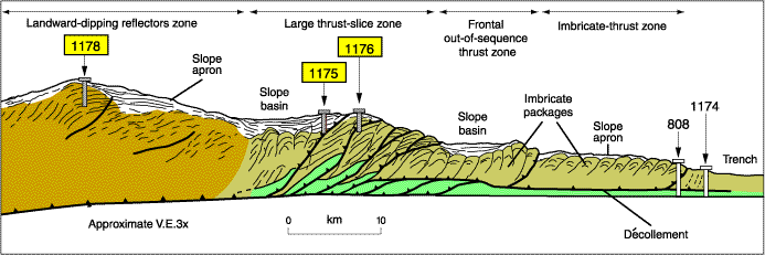
You can use the drill hole labeled 808 to see where the seismic image shown above is from. All of the thick black lines with saw teeth on them are thrust faults. You can get an idea about the size of the area shown in the cross section by looking at the scale shown at the bottom of the image.
I picked Nankai because it was the first subduction zone that came to mind. If there’s another one that you’d care to see let me know.
A change of direction?
Post #78I don't want to hijack this thread and end the very interesting discussions that people are having, but there's a lot of information in this thread; enough for an intro geology class in my opinion. I think a way to break up a discussion of plate tectonics into manageable chunks would be to take a modern plate margin, and then to trace the history of that margin back in geologic time. I think that the east coast of North America would be a good place for this – start with data that show North America and Europe are moving apart, follow that with the formation of the Atlantic Ocean, followed by the formation of the Appalachians, followed by the formation of the oceans that were subducted to form the Appalachians, etc.
This would allow much of the classic evidence for plate tectonics to be presented, and would also explore different types of plate boundaries.
What do people think?
This would allow much of the classic evidence for plate tectonics to be presented, and would also explore different types of plate boundaries.
What do people think?
-
otseng

- Savant
- Posts: 20984
- Joined: Thu Jan 15, 2004 1:16 pm
- Location: Atlanta, GA
- Has thanked: 218 times
- Been thanked: 393 times
- Contact:
Post #79
I would just like to take a brief intermission here and make some off-topic comments.
I'd like to say that this is a really fun thread. I guess there's something about stepping into a ring and you have one (or two) guys in one corner and a sizeable group of people in the other corner (15 according to the poll). I've never really thought much about plate tectonics before, but it's been interesting doing some research on it on my own and getting to challenge the theory.
Also, I think to answer the original question, "Is it a subject of debate?", I think the answer is a clear "yes". If it wasn't, this thread probably would've died off long ago. But, as it is, there are still many questions left unanswered in a satisfactory fashion about plate tectonics.
I'm also enjoying looking at all the diagrams. They really add a lot of value to the discussions and serve as good reference points for the discussions. I think there has been few other threads with the amount of interesting diagrams posted.
Lastly, with so many people on the opposing side, you'll have to be patient with me as I try to respond to the many posts in this thread. There are still many things that demand my attention outside of this forum (I still haven't done my taxes yet!). And I think just to participate in this thread alone requires a lot of my time. But, I'm enjoying every minute of it (this thread will probably make it as my nomination for the best debate thread of 2005).
Post #80
Thanks, John! The seismic images are exactly what I wanted. Now, I may be naive, but it seems like a couple of km of sediment qualifies as "lots." I think this meets otseng's expectation.
What is intriguing to me is the complexity of the images. They look like there's been a lot of moving and bumping and compressing, with all of the faults and all of the different segments that are visible in the images. The reconstruction of the wider area is particularly striking. This looks to me like information that meets another expectation: if the subduction zones really are moving, and sliding under the continents, then there should be a really messy pile-up as the ocean floor scrunches up before it is swallowed completely--kinda like trying to slide a cake into a box that's not quite tall enough, and the icing gets scrunched up as you push. It makes sense that there should be multiple faults, rather than having the same one slip all the time.
Now, let's see here....should we hijack the debate and discuss just a single region like the US East Coast? As I think about this, I feel that it might be a good thing to do. You're right, John, that this has become a lot like a geology class--but it differs in one significant respect. The information that has been presented has always been in response to questions. This makes the information much more understandable, because we have a context into which to put the information when we see it. Discussing the east coast and the formation of the Applachians might extend this to "ancient history." We can't explain the Appalachians by measuring current motion, then extrapolate back in time, and say "see, that explains it!" We'll have to go at least one step further, and look at geological clues as to what happened before the Atlantic opened up. That should be fun.
I'll also comment briefly on otseng's post. I agree that it is disappointing to have only one or two guys in one corner, and over a dozen in the other. I suspect, however, that this reflects a certain hesitation on the part of the tectonics-doubters. One could simply deny that the evidence exists (not a winning strategy, but common for the evolution debate), or one can think about the evidence, and ask whether it really justifies the conclusions. The latter is more difficult, and puts one at risk of deciding that, maybe, the evidence really does justify the conclusions. I suspect that not many creationists are willing to take that risk.
This leads me to the next thought. I'm not convinced that this thread has survived as long as it has because the subject is hotly contested. Rather, I think it has thrived because of otseng's perseverence. I see this not so much as a debate of one against 15, but rather an opportunity to hear and address the hard questions that usually are just 'bleeped over.' You know, "yeah, but what's the evidence?" Every science class needs an otseng!
Panza llena, corazon contento
