Difflugia wrote: ↑Mon Nov 22, 2021 3:21 pm
otseng wrote: ↑Mon Nov 22, 2021 10:26 am
The pattern I talk about is the massive erosion after all the layers have been deposited and the layers themselves have little record of geologic activity.
That pattern doesn't even exist in the Grand Canyon. There's evidence of lots of geologic activity and I've pointed you to descriptions of it.
When I say pattern, I'm talking about majority of cases, not
all the cases. The only two major activities you've mentioned in the Grand Canyon is the Great Unconformity and the final erosion we see now. There are hundreds of millions of years of other layers to account for and as you've said are geologically stable. The Great Unconformity and the final erosion only represent a short time period of the entire GC strata. They would be the exception, not the rule. When I speak of a pattern, I'm referring to the general pattern of all the strata. Yes, there will be deviations from the pattern, but they are rare. Demonstrating exceptions to the pattern do not signal the pattern does not exist in the general case.
It might be interesting if all of the canyons you mentioned on different continents showed all of the same erosion plain unconformities as the Grand Canyon and they either date to the same period or (because I know you deny the validity of radiometric dating) show the same kinds of sediment above and below the unconformities.
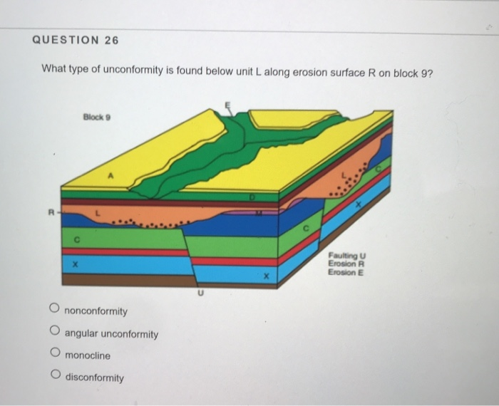
The SG cannot predict unconformities. I don't see why the FM would need to. Further, unconformities is only a problem with models with deep time.
Remember that there are many unconformities in the upper layers of the Grand Canyon. You have neither acknowledged nor refuted that, so I'm not sure if you're including those in your "little record of geologic activity" or are just ignoring them.
Actually, it's more problems for SG to account for. As mentioned before, either there was no geologic activity for millions of years (why should that happen?) or entire sets of stratum were scraped off leaving a layer parallel with the one under it (how can that happen?).
I'm also still hazy on your idea of "worldwide." It's obviously absurd if I point out several deserts (Sahara, Mojave, Gobi, Negev) and then claim that the entire world is desert
We are talking about the sedimentary strata. So, anywhere worldwide that sedimentary layers exist.
Most of the Earth's surface shows geological patterns different from those at the Grand Canyon. The Huron Mountains that I mentioned show a completely different geology, yet were apparently under the same Flood.
Yes, mountains were formed differently, which the FM accounts for as well.
otseng wrote: ↑Mon Nov 22, 2021 10:26 am
And to confirm, we all agree the sedimentary layers are flat is due to all the layers have been formed under water?
With the caveat that you've neither confirmed nor denied that there are multiple erosion unconformities representing periods where the land was not underwater, then yes.
Very good.
So, to clarify, the unconformities were not underwater?
otseng wrote: ↑Mon Nov 22, 2021 10:26 amFor a palaeochannel that is visible on the surface, it's probably not of significance since it's explainable by recent sediments filling in a dried up river bed. If it's a palaeochannel that is embedded in the strata, it's a little harder to explain. Since layers are formed underwater, the land would have to rise so its above the water, then a river would form, then it would have to be lowered to be underwater again for additional layers to be deposited on top of that.
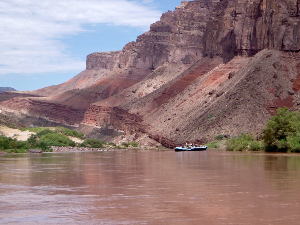
Exactly. That's why I picked the channel I did. The sedimentary layer representing the deposition of river sediment is buried under 10- to 20-million-year-old volcanic rock and only "partially re-excavated."
I don't see how your example demonstrates your point if we agree if it's recent it's easily explainable. 10-20 MYA would represent the most recent layers of the entire Grand Canyon strata. So, for your example that you gave, from the FM perspective, it would've occurred after the flood.
Again, you're being vague and I'm not even looking it up this time. I'm going to guess that the "vast" areas are smaller than you think they were.
In my next post I'll show one example of how vast an area we're talking about with buttes/mesas.
First. the sea level was higher than it is now during much of the
Paleozoic and
Mesozoic eras when much of the sediment was deposited.
Second,
we do, subject to your presentation of a source that both confirms the "vast areas" that you're claiming and is less vague about what that means.
Highly unlikely a continental shelf would be a candidate for sedimentary rock formation.
We have areas of sedimentary rock much larger than this. As a matter of fact, most of the surface land is comprised of sedimentary rock.
"The sedimentary rock cover of the continents of the Earth's crust is extensive (73% of the Earth's current land surface[1]),"
https://en.wikipedia.org/wiki/Sedimentary_rock
"Sedimentary rocks cover up to 75% of the Earth's surface."
https://wiki.seg.org/wiki/Sedimentology
Unless it's claimed continental shelf-like areas was much larger in the past.
Another problem is sedimentary strata contains fossils of land animals. So, how can an area like the continental shelf fossilize land animals?
And I'm contesting that anything is as flat as you seem to think it is. I've given you multiple sources describing ancient geological features all across the Colorado Plateau that are anything but what I would call flat.
It's from looking at the parallel layers themselves in the strata. If they are parallel, then it must've been flat.
That's precisely my point. The North American plate stays on top. It is not going under the Pacific plate and being recycled into the earth.
Sediment that was deposited into the ocean to the south and west of the Colorado Plateau was.
So, you're saying even though it is the Pacific plate, and not the North American plate, that is being subducted, sediments from the Grand Canyon was carried over 300 miles and then subducted? So the North American plate was also subducted?