Questions for Uniformitarianists

Creationism, Evolution, and other science issues

Moderator: Moderators

User avatar
otseng
Savant
Posts: 20668
Joined: Thu Jan 15, 2004 1:16 pm
Location: Atlanta, GA
Has thanked: 205 times
Been thanked: 348 times
Contact:

Questions for Uniformitarianists

Post #1

Post by otseng »

Uniformitarianism is one of the most important unifying concepts in the geosciences. This concept developed in the late 1700s, suggests that catastrophic processes were not responsible for the landforms that existed on the Earth's surface. This idea was diametrically opposed to the ideas of that time period which were based on a biblical interpretation of the history of the Earth. Instead, the theory of uniformitarianism suggested that the landscape developed over long periods of time through a variety of slow geologic and geomorphic processes.

The term uniformitarianism was first used in 1832 by William Whewell, a University of Cambridge scholar, to present an alternative explanation for the origin of the Earth. The prevailing view at that time was that the Earth was created through supernatural means and had been affected by a series of catastrophic events such as the biblical Flood. This theory is called catastrophism.

Source: PhysicalGeography.net

Uniformitarianism is a geological doctrine. It states that current geologic processes, occurring at the same rates observed today, in the same manner, account for all of Earth's geological features. Thus, it assumes that geological processes are essentially unchanged today from those of the unobservable past, and that there have been no cataclysmic events in earth's history. As present processes are thought to explain all past events, the Uniformitarian slogan is, "the present is the key to the past."

Source: Uniformitarianism.net

Some questions for uniformitarianists:
Why are there distinct lines between the sedimentary layers?
Why are they parallel to each other?
How did the stratas get formed?
Where did all the material come from to form the stratas?
Where do we see evidence of stratas being formed now?
Why do the majority of faults split through multiple layers?
Why do sedimentary stratas generally start in the Cambrian layer? Why are there none before that?
Do sedimentary layers exist older than 500 MYA?
Why are there little to none sedimentary stratas on top of shields (exposed cratons)?
Why are there relatively little sediments on the ocean floors near the ridges?
Why are there gaps in time in the stratas?
If those layers got eroded away, how did it happen?

John S
Student
Posts: 40
Joined: Wed Oct 20, 2004 8:04 am
Location: Bay Area, California

Re: Questions for Uniformitarianists

Post #11

Post by John S »

Hi otseng,

This is my first post to the board. I've been lurking for a while, and I've enjoyed the discussions I've read. I admire the civil tone of this board.
otseng wrote:
Some questions for uniformitarianists:
Why are there distinct lines between the sedimentary layers?
Why are they parallel to each other?
How did the stratas get formed?
Where did all the material come from to form the stratas?
Where do we see evidence of stratas being formed now?
Why do the majority of faults split through multiple layers?
Why do sedimentary stratas generally start in the Cambrian layer? Why are there none before that?
Do sedimentary layers exist older than 500 MYA?
Why are there little to none sedimentary stratas on top of shields (exposed cratons)?
Why are there relatively little sediments on the ocean floors near the ridges?
Why are there gaps in time in the stratas?
If those layers got eroded away, how did it happen?
The websites that you linked to don't give an adequate definition of uniformitarianism. No geologist that I've encountered trys to claim that only modern processes operating at modern rates are responsible for the formation of the rock record. For example, what about large meteorite impacts? They haven't happened in historic times, and yet geologists think they've happened a lot in earth's history.

I've only got a couple of minutes before I go to work so I can't address all these points now, but here's a couple:

Why are there distinct lines between the sedimentary layers?

Sometimes the contacts are sharp, sometimes they are gradational. A sandstone can gradually become muddier until it becomes a shale, or vice versa. It depends on how quickly the environment of deposition changes.

Where did all the material come from to form the stratas?

Topographic highs like mountain belts. For example there's a very thick series of sediments called the Catskill Delta that were eroded during an ancient mountain building event in the Appalachian region.

Where do we see evidence of stratas being formed now?

Pretty much everywhere sediments are being deposited. The seismic reflection profile at this link shows the sediments in part of Puget Sound. The triangles on that image mark the base of Holocene (very young) sediments. You'll notice that you can see strata. You can see them in the older sediments toward the bottom of the image too:

http://earthquake.usgs.gov/regional/pac ... fig7f.html

Why do the majority of faults split through multiple layers?

Why shouldn't they? I don't understand this question. Should faults be confined to a single layer?

Why do sedimentary stratas generally start in the Cambrian layer? Why are there none before that?
Do sedimentary layers exist older than 500 MYA?


There's no correlation at all to the beginning of the Cambrian and the beginning of sedimentary strata. They Precambrian is loaded with layered sedimentary rocks.

John

John S
Student
Posts: 40
Joined: Wed Oct 20, 2004 8:04 am
Location: Bay Area, California

Post #12

Post by John S »

YEC wrote:Recumbent folds in layers of strata indicate that the strata was still soft when folded.
Think about it...if the rocks were hard...they would snap, crackle and pop....not bent in half.

I think the uniformatarian model needs some work.
Recumbent folds, or any other folds for that matter, don't indicate soft sediment deformation. The folds formed at depth, where temperature and pressure are greater than at the surface. Rocks deform differently at high pressure and temperature than they do under surface conditions.

Here's my favorite piece of evidence that folded rocks weren't soft:

Those folds occur in mountains, and while the mountains were being formed (and therefore while the folds were being formed) clasts of rock (like river cobbles) were being eroded from them.

http://www.talkorigins.org/faqs/lewis/#strength

This is a clear indication that the folded rocks were hard. How are you going to erode river cobbles from layers of loose mud and sand?

User avatar
bdbthinker
Student
Posts: 89
Joined: Thu Jan 20, 2005 11:50 am
Location: indiana

Post #13

Post by bdbthinker »

John Solum wrote: The websites that you linked to don't give an adequate definition of uniformitarianism. No geologist that I've encountered trys to claim that only modern processes operating at modern rates are responsible for the formation of the rock record. For example, what about large meteorite impacts? They haven't happened in historic times, and yet geologists think they've happened a lot in earth's history.
I thought this IS the definition of uniformitarianism. Every *source I've come across shows this is accurate. This is the direct opposite of **catastrophism. I'm new to the subject so this may not be accurate. Where do you find your definition of uniformitarianism?

* http://en.wikipedia.org/wiki/Uniformita ... science%29
http://geography.about.com/od/physicalg ... tarian.htm

** http://en.wikipedia.org/wiki/Catastrophism

Here's an interesting link on uniform vs catastrop
http://www.emporia.edu/earthsci/student/grabill1/
Image

John S
Student
Posts: 40
Joined: Wed Oct 20, 2004 8:04 am
Location: Bay Area, California

Post #14

Post by John S »

bdbthinker wrote:
I thought this IS the definition of uniformitarianism. Every *source I've come across shows this is accurate. This is the direct opposite of **catastrophism. I'm new to the subject so this may not be accurate. Where do you find your definition of uniformitarianism?

* http://en.wikipedia.org/wiki/Uniformita ... science%29
http://geography.about.com/od/physicalg ... tarian.htm

** http://en.wikipedia.org/wiki/Catastrophism

Here's an interesting link on uniform vs catastrop
http://www.emporia.edu/earthsci/student/grabill1/
I think I was unclear about my definition of uniformitarianism. The modern definition of uniformitarianism is not limited to ONLY present processes acting at present rates, although it does not exclude them. The modern conception of uniformitarianism includes both slow processes and fast/catastrophic processes. When the concept of uniformitarianism was first proposed in the late 18the and early 19the centuries it didn't have much room for catastrophic events, but that's not the case with the modern usage of the concept.

The links that you provide talk about this. From the first link (http://en.wikipedia.org/wiki/Uniformita ... science%29):

"In recent decades, the theory of uniformitarianism has been modified to reflect the discovery that catastrophic events occur today and have occurred in the Earth's past. The present is still the key to the past, meteorite impacts, giant earthquakes, tsunamis, and explosive volcanism occur today as they have in the past and these events provide punctuations in an over-all gradual process."

From the second link (http://geography.about.com/od/physicalg ... tarian.htm):

"Today, we hold uniformitarianism to be true and know that great disasters such as earthquakes, asteroids, volcanoes, and floods are part of the regular cycle of the earth."

From the third link (http://en.wikipedia.org/wiki/Catastrophism):

"Today most geologists combine catastrophist and gradualist standpoints, taking the view that Earth's history is a slow, gradual story punctuated by occasional natural catastrophic events that have affected Earth and its inhabitants."

So, uniformitarianism can included slow processes, but it is not limited to them. Occasional catastrophes (meteorite impacts and so on) are also part of the modern concept of uniformitarianism.

User avatar
Jose
Guru
Posts: 2011
Joined: Thu Sep 02, 2004 4:08 pm
Location: Indiana

Post #15

Post by Jose »

All of these questions have been addressed already, but I'll throw in my two cents' worth:
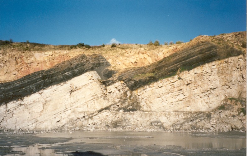
otseng wrote:Why are there distinct lines between the sedimentary layers?
As has been said, conditions changed. This doesn't mean that they changed in some regular way, though sometimes this seems to have happened. Some layers are very thick, others are quite thin. The Mancos Shale is 1000 feet thick in Black Mesa, near Chilchinbito, AZ. By contrast, the Moenkopi has lots of interleaved layers of sandstone and shale. Sandstone and shale are deposited under different conditions--think of fine sediment forming shale, and, well, sand forming sandstone.
otseng wrote:Why are they parallel to each other?
Why wouldn't they be, if they are deposited by sedimentation? We'd expect just what the Flood Geologists say, that they'd form horizontally under the force of gravity. The only difference is that Flood Geology posits that it happened suddenly, while traditional geology suggests that it took a very long time.
otseng wrote:How did the stratas get formed?
Where did all the material come from to form the stratas?
I'll lump these together. When mountains erode, the sediment is washed downhill. If it goes into lakes or oceans, it settles out, forming layers. Rivers also form strata, but they are much less extensive and much less uniform. Rivers tend to wander as they erode their banks, so fossil rivers (if that's what you want to call them) show up as braided sediments within other types of sediment. The example I think of is a river deposit at Hell Creek, MT, in the otherwise-volcanic ash sediment.
otseng wrote:Where do we see evidence of stratas being formed now?
As has been said, just about anyplace. Cores of lake sediment show layers of different types of material. If you fly over the southwest desert mountains, you can see very clearly the alluvial fans of erosional deposits at the mouths of the canyons. Glaciers have terminal morraines, which look a lot like the hills just south of Indianapolis.
otseng wrote:Why do the majority of faults split through multiple layers?
Again, as has been said, when faults slip, they break the rock above them, even if it is many layers thick.
otseng wrote:Why do sedimentary stratas generally start in the Cambrian layer? Why are there none before that?
This is a misconception promulgated by the Flood Geology of the Grand Canyon. As I posted recently, , it's pretty easy to see the layers even in the Vishnu Schist, the supposed "basement rocks" from before the flood. There are many other examples that can be found just noodling around on the web.
otseng wrote:Do sedimentary layers exist older than 500 MYA?
As noted above, yes. However, as previously mentioned, they are often referred to as metamorphic rock, rather than sedimentary, because of the time and pressure that has enabled them to metamorphose--from shale to slate, from limestone to marble, etc. The layers are still there, even if the crystal structure of the rock has been changed by compression.
otseng wrote:Why are there little to none sedimentary stratas on top of shields (exposed cratons)?
I picture this as the continental plates being, well, plates floating on the mantle. The plates are bouyant. They can tilt to one side or the other, but it's really hard to submerse them completely. Therefore, if a plate dips to the right, then the right side can get covered with sediment. If it dips to the left, then the left side can get covered with sediment. But, it's hard to cover the middle of the plate. Hence, we get sediments from which to build the Appalachians and the Rockies, but not much in Minnesota. [West of the Rockies it gets complicated, due to the various other, smaller plates crashing into the North American plate, and the stretching that formed the basin and range.]
otseng wrote:Why are there relatively little sediments on the ocean floors near the ridges?
The ridges are cracks in the ocean floor where molten material oozes out. This pushes the ocean floors outward, away from the cracks. The way the material oozes out, it forms ridges. As it pushes the ocean floor outward, it also pushes the continental plates along. Or, if the continental plate is being pushed on from both sides, the ocean floor may get forced down under the continental plate, producing the ocean trenches and the volcanism we see in places like the "ring of fire" around the Pacific.

The ocean floor near the ridges is very young, so it has had relatively little time to accumulate sediment.
otseng wrote:Why are there gaps in time in the stratas?
If those layers got eroded away, how did it happen?
The "how did it happen" part seems straightforward to me--just like erosion today. But, part of the story is lack of deposition, as well. If you think about where you live, you'll notice that you are above sea level, and you aren't getting buried in sediment every day. Where I live, the rocks on the surface are Mississippian rocks. A while back, they were formed underwater, but then they were lifted up above sea level. There has been no deposition on top of them since; instead, we see erosion. What would happen if this part of the North American plate tilted enough to put this region under water again? There would be renewed deposition of sediment, and future geologists would see an "unconformity" where the newer rock lies on top of Mississippian rock.
Panza llena, corazon contento

User avatar
Jose
Guru
Posts: 2011
Joined: Thu Sep 02, 2004 4:08 pm
Location: Indiana

Post #16

Post by Jose »

YEC wrote:Poly-strate fossils show a rapid deposit of sediment...like the flood would predict.
It is interesting to see what has already been said about polystrate fossils. Here's a brief excerpt:
Andrew MacRae wrote:The reason I am using Dawson rather than a more recent reference is to emphasize that many supposed "problems" with conventional geology were solved more than 100 years ago using very basic principles. The people suggesting these "problems" exist are so out of date that even 19th-century literature refutes their presentations.
This may be a bit brusque, but it does serve to indicate that the polystrate fossil "problem" was resolved some time ago.

It was resolved differently by a coal miner who was chatting with one of our paleontologists who was collecting fossils. The story was this (which I will cast as the miner's conversation, though, of course, I wasn't there so I don't know his true words):

"We find a lot of vertical tree fossils in the mines. We have to be careful of them, because if we make a tunnel just below one of them, then it is likely to come crashing down unexpectedly into the tunnel, as it slips out of the hollow around it. So, we watch for these pretty carefully.

"Now, I can see how The Flood would cause these things to be here. That's what I was always taught--that The Flood buried the forest, so there are a lot of fossil trees still in a vertical position. But, what I can't figure out how this explains the fact that we can make tunnels at many different levels in the mountain, and we find these vertical tree fossils at many different levels. I can see how The Flood might have wiped out one forest, but what about the other forests above and below? It must have taken a very long time to grow a new forest after The Flood, and then...was there another Flood?

"I've been working in these mines my entire life, and I just can't square what I see with what the Bible says. Either there were lots of Floods that the Bible doesn't talk about, or something else happened that was completely different from the Bible. I think you evolution guys must be right. You just can't interpret the Bible literally."
YEC wrote:Recumbent folds in layers of strata indicate that the strata was still soft when folded.
Think about it...if the rocks were hard...they would snap, crackle and pop....not bent in half.

I think the uniformatarian model needs some work.
I could suggest what would obviously happen if we tried to fold or bend a bunch of layers of gooey mud, but it really doesn't matter what we think seems like "common sense," because our "common sense" is based on our "common experience." We just can't experience the movement of rock deep inside the Earth. It takes too long to build a mountain for us to experience it. Gosh, look at glass. We think of it as pretty rigid stuff, but it's actually a very viscous liquid. We try to bend it, and it breaks. But if you look at the windows of a really old house, you'll see that the glass is thinner at the top of the window and thicker at the bottom. The glass is slowly flowing downhill under the force of gravity. We can make it flow faster by heating it up (the principle of glass blowing). But, we just can't perceive the movement as we stand there and watch a window.

Similarly, we can't perceive the bending of rock strata because the movement is just too slow. Besides, it's underground.

So, we can't reason from "common sense." We have to use what we might call forensic methods, and collect a lot of data to help us explain what actually happened.
YEC wrote:It makes one wonder how many instances of strata deposition there is that don't contain polystrate fossils which were actually laid down quickly...but given long time frames by the evo minded.

But as you pointed out...polystrate fossils are a great example of flood deposit. Ask Noah about the flood.
Certainly, there are many strata that were laid down quickly. The only reason this is "a problem" for creationists is that they pretend that geologists are "uniformitarians" in the sense of the word about 200 years ago. Oddly enough, geology has changed in the last 200 years, both in terms of what we know and with respect to the terminology. Using ancient terminology to poke fun at geologists is rather a weird strategy--unless you're trying to misrepresent science intentionally.

The important thing is to look at the data, and figure out what it tells us. If we can now recognize that some strata were laid down rapidly, while others were laid down slowly, great. It says nothing about 1800's-style "uniformitarianism."
Panza llena, corazon contento

User avatar
otseng
Savant
Posts: 20668
Joined: Thu Jan 15, 2004 1:16 pm
Location: Atlanta, GA
Has thanked: 205 times
Been thanked: 348 times
Contact:

Post #17

Post by otseng »

John Solum wrote:So, uniformitarianism can included slow processes, but it is not limited to them. Occasional catastrophes (meteorite impacts and so on) are also part of the modern concept of uniformitarianism.
I would agree. I would not say that it is an either/or proposition. Geologic features would be a explained through a mixture of of uniformatarianism and catastrophism. The question though is how much of each mixture. I think the main point is that for U16s (Uniformitarianists), most geological features were formed through a slow process. For C12s (Catastrophists), most geological features were formed quickly.
Sometimes the contacts are sharp, sometimes they are gradational. A sandstone can gradually become muddier until it becomes a shale, or vice versa. It depends on how quickly the environment of deposition changes.
To me, sharp lines would indicate some sort of rapid sedimentation process. It would have been some abrupt process to go from one type of sedimentation to another. But if U15m explains most of the stratas, then why are sharp lines the rule rather than the exception?
Pretty much everywhere sediments are being deposited. The seismic reflection profile at this link shows the sediments in part of Puget Sound. The triangles on that image mark the base of Holocene (very young) sediments. You'll notice that you can see strata. You can see them in the older sediments toward the bottom of the image too:

http://earthquake.usgs.gov/regional/pac ... fig7f.html
I would disagree with "pretty much everywhere". The example you gave is underwater sedimentation. I can see how water can cause sedimentation layers (esp parallel ones), but for places that are not underwater, how can it cause sedimentary layers?
Why do the majority of faults split through multiple layers?
Why shouldn't they? I don't understand this question. Should faults be confined to a single layer?
Here is a typical cross sectional picture of a fault:
Image
The fault line goes through multiple stratas, all the way to the top. This is commonly what we see in faults.

Now, let's take a thought experiment. Let's take the U15m geologic timescale and start with Cambrian layer (488 MYA). I think it would safe to say that some faults should occur back then. The fault lines would form only from the Cambrian layer on down. More sedimentation then got deposited on this. So, the Ordovician layer that got layed down on top of this would not have the fault line. We should see the fault line in the Cambrian layer, but not in the Ordovician layer. And we should continue on in the same manner for 488 million years up to the present. Therefore, what we should expect to see is many fault lines that go from the bottom-most layer and up to the layer when the fault occured. The next layer above that would have no evidence of a fault since the layer got deposited after the fault occured. So, if U15m is true, the majority of fault lines should be like this. If C11m is true, we should see little if any faults like this, rather we should see faults that extend all the way to the top-most layer. And from images of faults that I have seen, this is indeed the case.
Precambrian is loaded with layered sedimentary rocks.
You'll have to provide evidence for this. From this source, it states "The composition of the Precambrian rocks is generally composed of granite, schist, or gneiss." And also this source states, "Drillers commonly refer to the Precambrian rocks as the "granite," in reference to a common rock type found below the Paleozoic rocks."
Jose wrote:
otseng wrote:Why are they parallel to each other?
Why wouldn't they be, if they are deposited by sedimentation? We'd expect just what the Flood Geologists say, that they'd form horizontally under the force of gravity. The only difference is that Flood Geology posits that it happened suddenly, while traditional geology suggests that it took a very long time.
Flood geologists would say that gravity plus water would form parallel layers. If there is no water present, how can parallel layers form? If we take a walk outside, we do not see regularly see large flat areas accumulating sediments. We do not even commonly see large flat areas except in desert areas. So, if water is not present, how can parallel layers form?
otseng wrote:How did the stratas get formed?
Where did all the material come from to form the stratas?
I'll lump these together. When mountains erode, the sediment is washed downhill. If it goes into lakes or oceans, it settles out, forming layers.
Right, sediments must come from a higher elevation. But, how then did all the layers form? Suppose we start at the Cambrian layer, the sediments to form it must have come from sediments higher than the Ediacaran layer. And each successive layer has this problem. Where did the sediments for each layer come from if it had to come from a higher elevation?
otseng wrote:Where do we see evidence of stratas being formed now?
As has been said, just about anyplace. Cores of lake sediment show layers of different types of material. If you fly over the southwest desert mountains, you can see very clearly the alluvial fans of erosional deposits at the mouths of the canyons. Glaciers have terminal morraines, which look a lot like the hills just south of Indianapolis.
The examples you gave all have water as a common element. So, it is not just anyplace, but anyplace where there is water.
I picture this as the continental plates being, well, plates floating on the mantle. The plates are bouyant. They can tilt to one side or the other, but it's really hard to submerse them completely.
I'll have to start a thread sometime to discuss plate tectonics.
otseng wrote:Why are there gaps in time in the stratas?
If those layers got eroded away, how did it happen?
The "how did it happen" part seems straightforward to me--just like erosion today.
The problem is, how can erosion cause parallel layers?

Another thought experiment. Let's start with a set of layers. Then erode it through weathering process. Then add more layers on top of that. Then repeat. What we should see is something like diagram D below. But, that is the exception in what we see rather than the rule. What we commonly see is diagram E, which is consistent with C11m.
Image

gabbro
Newbie
Posts: 7
Joined: Tue Mar 15, 2005 5:33 pm

Post #18

Post by gabbro »

juliod wrote:
Note, BTW, that creationists have made zero contribution to geology over the last, say, 100 years.

DanZ
Because Geology is property of secular institutions. If you claim to be YEC, you're not going to get into a graduate program and get funded by a professor. They won't invest their research dollars in you. You have to write research proposals to get money for research. Do you really think modern science is going to fund someone who wants to disprove the whole basis of what they believe? Be real about this. Geology is too biased to even consider the idea...they just write off YEC as religious quacks. BTW, I have a Geology degree and I've heard the rhetoric against YECs. I personally don't think there's enough evidence for OEC or YEC, either way and isn't that woderful that we still have some mysteries about the wonder of God's creation?

The only reason this becomes important at all is that Macro-Evolutionists HAVE to have billions of years for their theory to work. Isn't that something? They have to impose a timeline..forget researching the timeline. The Geologic record was created LONG before any age dating methods, by Lyell and he influenced Darwin...who by the way, he never agreed with. Lyell was purposely trying to disprove God and creation. I can't trust that kind of science that is already looking for an answer before it starts. It's shameful. I think it's shameful for YECs to make the same kind of assumptions. Without the debate of evolution, would the age of the earth even matter?

Think about it....you date the fossils by the rock layers they are in and the rock layers by the fossils that are in them...what? You do age dating and you throw out the dates that don't fit the "geologic time scale". Seems like an awful lot of compromises in a discipline that is about facts.

John S
Student
Posts: 40
Joined: Wed Oct 20, 2004 8:04 am
Location: Bay Area, California

Post #19

Post by John S »

otseng wrote: I would agree. I would not say that it is an either/or proposition. Geologic features would be a explained through a mixture of of uniformatarianism and catastrophism. The question though is how much of each mixture. I think the main point is that for U16s (Uniformitarianists), most geological features were formed through a slow process. For C12s (Catastrophists), most geological features were formed quickly.


Hi otseng, it's nice to hear from you. I think you're making an unjustified distinction between what you're calling uniformitarianism and catastrophism. Uniformitarianism does not automatically imply slow processes. Correct me if I'm wrong, but it seems to me like the two schools of thought that you're talking about are conventional geologists, who'd argue that the rock record isn't the result of a single event, and flood geologists, who'd argue that the rock record is (at least almost entirely) the result of a single event (the Flood of Noah). Along those lines you seem to be arguing that the presence of sedimetary bedding should be an indicator of this event. Am I understanding correctly?
otseng wrote: To me, sharp lines would indicate some sort of rapid sedimentation process. It would have been some abrupt process to go from one type of sedimentation to another. But if U15m explains most of the stratas, then why are sharp lines the rule rather than the exception?
Sharp contacts don't definitively indicate rapid sedimentation, all they indicate is a change in depositionial environment (or they may represent an unconformity - a period when there's no sedimentation). For example, if a river channel migrates, you'll wind up with sands and conglomerates deposited on top of floodplain deposits (silts). You can see examples of this in both modern (like the Mississippi River) and ancient depositional environments (http://talc.geo.umn.edu/courses/4602/Sp ... /2230.html) For another example, if sea level rises what are currently beaches (sands) will be covered by deeper water deposits like silts. Finally, a sharp contact may coincide with rapid deposition, but rapid deposition doesn't automatically indicate something like Noah's flood. Hurricanes, earthquakes, tsunamis, etc. (pretty mundane events compared to something like Noah's flood) can all result in abrput changes in sedimentary deposits. Trying to take separate "catastrophic" events in the rock record and use them as evidence of a single global event would be like using the deposits from hurricanes in Florida and typhoons in the Pacific as evidence of a global storm. Not to mention that taking that approach also ignores all of the rock record that has features indicating slower deposition (things like worm burrows). I get the impression from your posts that you're claiming that all post-Cambrian rocks are Flood rocks. If that's the case they shouldn't have features like burrows (among many others), but they do.
otseng wrote: I would disagree with "pretty much everywhere". The example you gave is underwater sedimentation. I can see how water can cause sedimentation layers (esp parallel ones), but for places that are not underwater, how can it cause sedimentary layers?
I may be missing something, but I don't see how your question is relevant. Do you think conventional geologists claim most of the rock record wasn't deposited underwater (in the ocean, or in lakes or rivers)? Most of it was, but there are deposits from things like deserts. What sort of areas are you talking about? It seems to me that the point you were trying to make in your original post is that sedimentary bedding can't be explained by conventional geology, and therefore that sedimentary bedding indicates a global flood. If sedimentary bedding is forming today, underwater or otherwise, then I don't see how you can support your contention that it can only form during a global flood. Would you mind expanding on this a bit?

otseng wrote: The fault line goes through multiple stratas, all the way to the top. This is commonly what we see in faults.
Going "all the way to the top" of an exposure, like the fault in the quarry face that you linked to, is very different than a fault cutting through Cambrian through modern rocks. The website you linked to provides a breif description of the geology of the fault in the photo:
http://www.fault-analysis-group.ucd.ie/ ... faults.htm
From their description the fault cuts Upper Carboniferous rocks ( a small segment of the rock record). That's not an example of a fault cutting Cambrian through modern rocks. You're not justified in saying that because the fault cuts all of the rocks in a cliff or a quarry face, that those faults cut through rocks of Cambrian to modern age. More on this below.

otseng wrote: Now, let's take a thought experiment. Let's take the U15m geologic timescale and start with Cambrian layer (488 MYA). I think it would safe to say that some faults should occur back then. The fault lines would form only from the Cambrian layer on down. More sedimentation then got deposited on this. So, the Ordovician layer that got layed down on top of this would not have the fault line. We should see the fault line in the Cambrian layer, but not in the Ordovician layer. And we should continue on in the same manner for 488 million years up to the present. Therefore, what we should expect to see is many fault lines that go from the bottom-most layer and up to the layer when the fault occured. The next layer above that would have no evidence of a fault since the layer got deposited after the fault occured. So, if U15m is true, the majority of fault lines should be like this. If C11m is true, we should see little if any faults like this, rather we should see faults that extend all the way to the top-most layer. And from images of faults that I have seen, this is indeed the case.
Your thought experiment sounds reasonable to me, and your "uniformitarian" style of faulting is what is observed. There are faults that cut rocks no older than Cambrian, just as there are faults that cut rocks no older than Ordovician (and so on for every other geologic period). Here's a very brief list of episodes of deformation (folding and faulting during mountain building) called orogenies in North America:

Grenville Orogeny: This occurred in the Late Precambrian (~1.1-0.9 billion years ago). Grenville faults don't cut rocks younger than Late Precambrian (i.e., they don't cut Late Precambrian through Holocene rocks, but they do cut rocks older then Late Precambrian).

Taconic Orogeny: This occurred in the eastern U.S. in the Ordovician (Taconic strucutres don't cut rocks younger than Ordovician)

Acadian Orogeny: This occurred in the eastern U.S. in the Devonian (Acadian strucutres don't cut rocks younger than Devonian)

Anlter Orogeny: This occurred in the western U.S. in the Devonian

Alleghanian Orogeny: This occurred in the eastern U.S. during the Carboniferous

Sonoman Orogeny: This occurred in the western U.S. during the Permian (and its structures don't cut rocks younger than Permian)

Sevier Orogeny: This occurred in western North America during the Cretaceous and Tertiary periods (and its structures don't cut rocks younger than those times).

There are faults that cut through Precambrian to modern rocks, but that doesn't indicate anything unusual. All that means is that the fault was active in modern times (like the San Andreas).
otseng wrote: You'll have to provide evidence for this. From this source, it states "The composition of the Precambrian rocks is generally composed of granite, schist, or gneiss." And also this source states, "Drillers commonly refer to the Precambrian rocks as the "granite," in reference to a common rock type found below the Paleozoic rocks."
Asking for evidence is fair. I can't list all of the Precambrian sedimentary rocks in the world, but it's informative to use "Precambrian sedimentary rocks" as a Google search. The ones that come first to my mind are the Belt Supergroup (thousands of feet of sandstone, limestone, and shale - some of it lightly metamorphosed) in western North America (~740 Ma), the Grand Canyon supergroup (similar in age to the Belt supergroup), and the Uinta formation of Utah (similar age).

Here's a book titled "Precambrian Sedimentary Environments"
http://www.blackwellpublishing.com/book ... 0632064153

It is true that there are a lot of metamorphic Precambrian rocks, but not all Precambrian rocks are metamorphic. The links you provide can't be used to represent the Precambrian as a whole, they're brief descriptions of local geology. In additon, both of your links talk about Precambrian sediments.

The final point I want to make is that sedimentary bedding isn't unusual - it's found in Precambrian rocks, it's found in post-Precambrian rocks, and it's found in modern sediments. Given this observation, I don't see how the presence of sedimentary bedding can be used as evidence of Noah's Flood.

The rest of your post doesn't appear to be addressed to me, so while there are a lot of interesting topics that I wouldn't mind discussing, I'll leave them be for the moment.

User avatar
otseng
Savant
Posts: 20668
Joined: Thu Jan 15, 2004 1:16 pm
Location: Atlanta, GA
Has thanked: 205 times
Been thanked: 348 times
Contact:

Post #20

Post by otseng »

John S wrote: Hi otseng, it's nice to hear from you.
And to you as well. I've been preoccupied at work lately and haven't been able to participate in the debates as much as I would like. But now that I've over the first major hurdle, I'm hoping I'll have more time to devote to the C vs E topics again.
Correct me if I'm wrong, but it seems to me like the two schools of thought that you're talking about are conventional geologists, who'd argue that the rock record isn't the result of a single event, and flood geologists, who'd argue that the rock record is (at least almost entirely) the result of a single event (the Flood of Noah). Along those lines you seem to be arguing that the presence of sedimetary bedding should be an indicator of this event. Am I understanding correctly?
Correct. I have stated my position in many different threads in the C vs E subforum, but probably the most comprehensive place to find my viewpoint is in the Global Flood thread.
Sharp contacts don't definitively indicate rapid sedimentation, all they indicate is a change in depositionial environment (or they may represent an unconformity - a period when there's no sedimentation).
It would appear to me that if a layer was deposited slowly with a different sediment composition, weathering processes would at the same time affect the current exposed layer. This would cause a more gradual delineation between the two layers. If there were no weathering process to affect the base layer so that no sediments from the base layer could move and mix with the new layer, I can see how a a slow sedimentation might cause distinct lines. Another problem is that not only are lines generally distinct, but they are parallel to each other for large sections of land. I cannot see how a slow process can achieve this.

Another question this brings up is what exactly causes changes in depositional material? For instance, in the Grand Canyon, we see layers that are hundreds of feet thick each spanning millions of years. So, for millions of years, one particular type of sedimentation was deposited. Then it abruptly (relatively speaking) changes to another depositional material and that was layed down for another several million years. What would cause these changes? And why was only one type of sedimentation able to be deposited for millions of years? Why millions of years instead of say, thousands, or decades of years?
I get the impression from your posts that you're claiming that all post-Cambrian rocks are Flood rocks.
Your impression is correct.
otseng wrote: I would disagree with "pretty much everywhere". The example you gave is underwater sedimentation. I can see how water can cause sedimentation layers (esp parallel ones), but for places that are not underwater, how can it cause sedimentary layers?
I may be missing something, but I don't see how your question is relevant. Do you think conventional geologists claim most of the rock record wasn't deposited underwater (in the ocean, or in lakes or rivers)?
Here is the problem, if sedimentary layers are formed by water, why do we have sedimentary layers at practically every place on the land surface? If it is formed underwater, would it then not be expected to see more sedimentary layers underwater that on the land? This is actually the opposite of what we see.
Most of it was, but there are deposits from things like deserts.
Could you provide some examples of deposits forming in deserts?
It seems to me that the point you were trying to make in your original post is that sedimentary bedding can't be explained by conventional geology, and therefore that sedimentary bedding indicates a global flood.
My point is that conventional geology has many questions that needs to answered. And the global flood fits better with the data that we see (of course, I realize that many do not share my beliefs).
If sedimentary bedding is forming today, underwater or otherwise, then I don't see how you can support your contention that it can only form during a global flood. Would you mind expanding on this a bit?
Certainly I believe sedimentary bedding is being formed today. But I do not believe a slow process can adequately explain many of the questions I have posed.
The rest of your post doesn't appear to be addressed to me, so while there are a lot of interesting topics that I wouldn't mind discussing, I'll leave them be for the moment.
I'll have to leave as well and resume later. But my posts are open for anyone to address.

Post Reply