A Deluge of Evidence for the Flood?

Creationism, Evolution, and other science issues

Moderator: Moderators

Post Reply
User avatar
LittlePig
Sage
Posts: 916
Joined: Mon Feb 04, 2008 1:51 pm
Location: Dallas, TX

A Deluge of Evidence for the Flood?

Post #1

Post by LittlePig »

otseng wrote:
goat wrote:
otseng wrote:
LittlePig wrote: And I can't think of any reason you would make the comment you made if you weren't suggesting that the find favored your view of a worldwide flood.
Umm, because simply it's a better explanation? And the fact that it's more consistent with the Flood Model doesn't hurt either. ;)
Except, of course, it isn't consistent with a 'Flood Model', since it isn't mixed in with any animals that we know are modern.
Before the rabbits multiply beyond control, I'll just leave my proposal as a rapid burial. Nothing more than that. For this thread, it can just be a giant mud slide.
Since it's still spring time, let's let the rabbits multiply.

Questions for Debate:

1) Does a Global Flood Model provide the best explanation for our current fossil record, geologic formations, and biodiversity?

2) What real science is used in Global Flood Models?

3) What predictions does a Global Flood Model make?

4) Have Global Flood Models ever been subjected to a formal peer review process?
"Well thanks a lot, Plato." - James ''Sawyer'' Ford
"Don''t flip ya lid." - Ricky Rankin

User avatar
micatala
Site Supporter
Posts: 8338
Joined: Sun Feb 27, 2005 2:04 pm
Has thanked: 1 time

Post #261

Post by micatala »

otseng wrote:
micatala wrote: But what about the lack of "dead seismic zones" referred to? Shouldn't there be a lot more water than one might find in this hole and other possible not yet located holes?
I'm not able to determine what exactly is meant by a "dead seismic zone". Are you able to find out what this means?

Since the subterranean water is now on the surface of the Earth and the two rock layers have collapsed, I don't think there would be a significant amount of water at the boundary. But, there should at least be some water there. And as I mentioned earlier, this can be tested as we drill more superdeep holes in the future.

BTW, have you been able to think about my prediction that I gave earlier?
I was referring to a post by I believe it was Scotracer in which he indicated that certain types of seismic waves do not travel through water. Since we have not found pockets of water large enough for this phenomenon to occur (what I called seismic dead zones) this implies no large pockets of water.


I will also note I have now gone through the entire Global flood thread and have started a response to it. I may need some help in retreiving a saved draft and getting it into the thread.
" . . . the line separating good and evil passes, not through states, nor between classes, nor between political parties either, but right through every human heart . . . ." Alexander Solzhenitsyn

User avatar
Grumpy
Banned
Banned
Posts: 2497
Joined: Mon Oct 31, 2005 5:58 am
Location: North Carolina

Post #262

Post by Grumpy »

otseng
And after millions of years of erosion, even if it was an ice sheet, the end result is a flat surface? Where do we see such things occuring?
Worldwide, it is a common phenominon.
As for floating continents, plate tectonics even posit that plates "float" on rocks.
A distortion of what the theory(and copious evidence)indicates. The "rock" is in a very hot form, either plastic or molten(again, depending on the specific location).
find gasses underground, but that does not mean the Earth is blown up like a huge basketball.
Nobody is claiming that.
But the claim that finding some water at depth means that the FM of contenents floating on water is equally as ludicrous.
Actually, the evidence supports the FM better than does the plate tectonics explanation.
Were that true(and it is not), the scientists of the world would be using the FM INSTEAD of the Plate Tectonics model. Too much evidence of the volcanic functioning of our world precludes such a myth based conclusion.
Plate tectonics says that lava is pushing the plates apart and created the oceanic ridge. But, when lava comes out of the ground, is comes out radially, not forming straight lines.
Again with the distortion and oversimplification. The Mid Atlantic ridge can in no way be classified as a straight line, it actually mimics the outline of the rift between the Euopean Continent and the North American one. The sea floor between Europe and America has also been thuroughly studied and the time line for it's formation stretches for hundreds of millions of years, not thousands or tens of thousands. We are still seeing that distance grow today, by the same forces which formed it in the first place, lava flowing up to build new land as the plates seperate.

Image

Image

"In contrast to the point-source, centralized eruptions that typify most volcanoes, fissure eruptions are generated at several contemporaneous sites along a linear fracture, or along an en echelon (parallel, but offset) fracture system, such as that shown in the image here. Regional fracture systems can appear where the Earth's crust is broken and pulled apart by tensional forces. If these regions are underlain by reservoirs of basaltic magma, this low-viscosity melt will utilize the fractures and ascend through the crust to generate a fissure eruption. For example, Mid-oceanic ridges (divergent plate margins) typically extrude basaltic magma from fissure eruptions because these are areas where global-scale extension is coincident with the rise of partially molten asthenosphere. Because Iceland is the subaerial extension of the Mid-Atlantic Ridge, it is one of the world's most active sites for basaltic fissure eruptions. For this reason, fissure eruptions are also known as Icelandic eruptions. The largest lava flow in recorded history was generated by a fissure eruption in south central Iceland in 1783. Known as the Laki flow, it erupted from a 25-kilometer-long fissure to produce 12 cubic kilometers of lava, filling two deep river valleys and covering an area greater than 500 square kilometers."

http://www.geology.sdsu.edu/how_volcano ... ssure.html

So, yes Virginia, they do erupt in straight lines.
How did I "misuse" the article? I'm simply countering your claim "there IS of an impact event 65 million years ago that wiped out the dinosaurs." And that the Chicxulub impact has been shown to not cause their extinction.
You are using his argument about the cause for the extinction to try to handwave away the real point I was making about there being worldwide evidence of the meteor/comet impact itself. And the susequent question of why no worldwide evidence of any flood events. And, no Keller's hypothesis HAS NOT shown that the impact was not the cause. Again, too much evidence indicates it was, Keller is a long way from showing otherwise.

Grumpy 8-)
"Fear of God is not the beginning of wisdom, but it''s end." Clarence Darrow

Nature is not constrained by your lack of imagination.

Poe''s Law-Without a winking smiley or other blatant display of humor, it is impossible to create a parody of Fundamentalism that SOMEONE won''t mistake for the real thing.

User avatar
Chimp
Scholar
Posts: 445
Joined: Mon Jul 25, 2005 5:20 pm

Post #263

Post by Chimp »

My understanding of the current theory regarding the water saturated layer in
the super-deep bore hole, is that the tremendous pressure involved created
the water by fusing hydrogen and oxygen. The water was unable to be forced to the
surface because of an impermeable layer above the saturated layer.

It's also worth noting the temperature/pressure they encountered was hot enough
to make the rock they were drilling plastic. When they removed the drill bit
for replacement, the hole would fill in.

User avatar
otseng
Savant
Posts: 20984
Joined: Thu Jan 15, 2004 1:16 pm
Location: Atlanta, GA
Has thanked: 218 times
Been thanked: 393 times
Contact:

Post #264

Post by otseng »

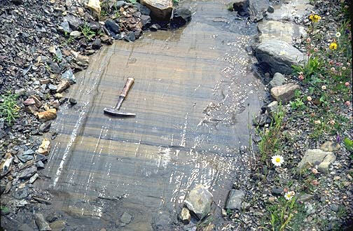
Scotracer wrote:Glacial erosion:

Image
More specifically in this picture, glacial abrasion.
The second process of erosion involves the abrasive action of the held rock and sediment held by the ice on the surface underneath the glacier. This abrasive process is known as scouring. Scouring creates a variety of features. The most conspicuous feature of scouring is striations (Figure 10af-1). Striations appear as scratches of various size on rock surfaces. In some cases, abrasion can polish the surface of some rock types smooth. This geomorphic feature is known as glacial polish.
http://www.physicalgeography.net/fundamentals/10af.html

This process smooths rocks, rather than "bulldozes" massive amounts of rock.

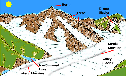
Also, taking a wider scope of glacial erosion, it doesn't account for horizontal erosion. Most glacial erosion causes sloped surfaces like the below diagram. So, glacial erosion doesn't produce a large flat horizontal area.

Image

User avatar
otseng
Savant
Posts: 20984
Joined: Thu Jan 15, 2004 1:16 pm
Location: Atlanta, GA
Has thanked: 218 times
Been thanked: 393 times
Contact:

Post #265

Post by otseng »

Scotracer wrote: Otseng if I'm right in saying, the superdeep borehole was the deepest of its kind and therefore you would only get one instance of water at that depth, by definition?
They did not expect to find any water at that depth since SG would not predict that. In the FM, it is explainable.
I note in the quote you held a post or two ago that the rock was "fully fractured". If what you propose occured the rock wouldn't have fractured as it collapse it would have melted with the energy and fused into new rock. Think of the forces in play here.
If two large sections of rock crashed into each other, I would expect it to fracture rather than melt and fuse. How would the SG explain why it's fractured?

User avatar
otseng
Savant
Posts: 20984
Joined: Thu Jan 15, 2004 1:16 pm
Location: Atlanta, GA
Has thanked: 218 times
Been thanked: 393 times
Contact:

Post #266

Post by otseng »

First off, thanks for the first thoughtful response to my prediction.
micatala wrote: I would think, however, that at a given location, sedimentary strata could be either very thick or somewhat thin, and could represent varying periods of time.
Yes. And even in some places, there are no sedimentary strata.
I could see that at a given location, sedimentary strata could be formed during era A, then no strata are formed for a time (perhaps a long time), then either more strata are formed on top of these or uplifting occurs at this location for a period, then erosion might occur, etc.
During the long period after A was deposited, couldn't something have happened to it? Like folding, erosion, faults, etc?
Also, I would think that in some cases, a thick (or maybe even a thin) layer could be layed down quickly, although it might take some additional time to harden.
Which raises another question. It would be assumed that when any layer is formed, it would not be hardened immediately. So, water and wind should be able to erode it and be recorded in the geologic record.
A volcanic mudflow (lahar sp?) for example could lay down a thick sedimentary layer in a short time on top of either other sedimentary layers, or other volcanic layers, and then one might get a lava flow on top of that.
Yes, it could do that.
So could an ordinary water flood.
Or even an extraordinary water flood.
Assuming there were no additional sedimentation (or other types of layers) layed down after a flood and subsquent deformation, it seems to me the flood model prediction is reasonable. I guess I need clarification on what this model assumes is below the strata layed down by the global flood, and whether this model includes subsequent layers being layed down years after the flood.
There would be no significant sedimentary layers deposited prior to the flood.

After the flood, there could be some additional layers deposited by volcanoes, local floods, or river sediments. But it would not be extensive.
I am not sure I would expect a "uniform" distribution in the stratas.
I wouldn't say uniform at any single location, but taking all locations around the world, I would expect if erosion, faults, folding occurred in the past, each location would be a snapshot of the history of that particular location, and they should all have past events evident in the stratas. There should be no reason that erosion, faults, folds should only be seen to affect all the layers at almost all places.
To the extent that strata tend to form in flat areas, and especially marine environments like continental shelves, I would expect that these areas tend to be very quiet, seismically speaking, during periods where strata are forming.
I would question that assumption. But even if it is quiet while a particular strata is forming, there is a large amount of time between when stratas form.
Conversely, I would expect that in most areas where folding/faulting/erosion are occurring, sedimentary strata are not being layed down at the same time.
In a concave (synform) fold, I would actually expect it catch more sediments than a flat surface.

Most mountains are the result of folding, but they also have a significant amount of deposits in them.
Now, over the long history of the earth, while I wouldn't expect "uniformity", I would expect to see instances of sedimentary layers subsequently undergoing folding, and faulting and this, I would think, would effect all they layers existing at the time the folding or faulting process was occurring.
Yes. But would this mean that once a fault occurs that the location could not have more layers deposited on it?
Erosion, on the other hand, as it works from the top down, would not effect all the layers, at least not simultaneously.
It would only work from the existing top surface on down. Water erosion from rain, beach, rivers, etc do not typically produce flat surfaces. So, shouldn't these be evident in the sedimentary stratas?
I believe some of the examples pointed to earlier in the thread do actually show this.
Just looking at the Siccar Point Unconformity, there are still many questions that SG does not answer.
One prediction you did not make which I think follow from a flood, especially a recent one, is that we should find fossils of the life that existed at the time of the flood all mixed together.
The flood was not simply water that covered the earth, but a mixture of water and earth. It would be more akin to a mud slide than a flash flood. So, I think what would be more expected is quick and mass burials of plants and animals.
THus, we should find heavier life forms in the lowest layers and the lightest life forms at the top, or at least a significant trend in this direction.
There would not be a significant time for heavier things to sink and lighter things to float. Rather, they would've instantly been swept away and/or buried.

Elvis Trout
Student
Posts: 73
Joined: Mon May 25, 2009 7:29 pm
Location: Royston Vasey

Post #267

Post by Elvis Trout »

Where did all the water come from? Is there enough in the atmostsphere to cover all the land there was then? Or did it start raining and then the land sank at the same time?

User avatar
otseng
Savant
Posts: 20984
Joined: Thu Jan 15, 2004 1:16 pm
Location: Atlanta, GA
Has thanked: 218 times
Been thanked: 393 times
Contact:

Post #268

Post by otseng »

micatala wrote:I was referring to a post by I believe it was Scotracer in which he indicated that certain types of seismic waves do not travel through water. Since we have not found pockets of water large enough for this phenomenon to occur (what I called seismic dead zones) this implies no large pockets of water.
There are seismic anomolies that would point to water deep underground.

3-D seismic model of vast water reservoir revealed
A seismologist at Washington University in St. Louis has made the first 3-D model of seismic wave damping " diminishing " deep in the Earth's mantle and has revealed the existence of an underground water reservoir at least the volume of the Arctic Ocean.
I will also note I have now gone through the entire Global flood thread and have started a response to it. I may need some help in retreiving a saved draft and getting it into the thread.
To retrieve a saved draft, go to the main page and click on "View your drafts and posts" on the top right. You can just post it here in this thread, rather than the Global Flood thread.

Elvis Trout
Student
Posts: 73
Joined: Mon May 25, 2009 7:29 pm
Location: Royston Vasey

Post #269

Post by Elvis Trout »

otseng wrote:
micatala wrote:I was referring to a post by I believe it was Scotracer in which he indicated that certain types of seismic waves do not travel through water. Since we have not found pockets of water large enough for this phenomenon to occur (what I called seismic dead zones) this implies no large pockets of water.
There are seismic anomolies that would point to water deep underground.

3-D seismic model of vast water reservoir revealed
A seismologist at Washington University in St. Louis has made the first 3-D model of seismic wave damping " diminishing " deep in the Earth's mantle and has revealed the existence of an underground water reservoir at least the volume of the Arctic Ocean.
That's just one scientist. That doesn't amount to much. Also he seems to have just confused 'water' with magma. I'd have to see more evidence really.

User avatar
Grumpy
Banned
Banned
Posts: 2497
Joined: Mon Oct 31, 2005 5:58 am
Location: North Carolina

Post #270

Post by Grumpy »

otseng
There are seismic anomolies that would point to water deep underground.
And as the article cited says, the standard geological model has a very good explanation of why it is there IN THAT PARTICULAR INSTANCE. "the long history of the subduction of oceanic lithosphere " crust and upper mantle " in this region."
They did not expect to find any water at that depth since SG would not predict that. In the FM, it is explainable.
The SG would not rule it out, and water is found underground all the time, BUT IT WILL NOT AND CAN NOT FLOAT CONTINENTS AROUND, AND CERTAINLY NOT SUDDENLY as you are suggesting happened.
This process smooths rocks, rather than "bulldozes" massive amounts of rock.

Also, taking a wider scope of glacial erosion, it doesn't account for horizontal erosion. Most glacial erosion causes sloped surfaces like the below diagram. So, glacial erosion doesn't produce a large flat horizontal area.
That is ONE of the results, Glacial moranes are the result of "bulldozing".

Glacial erosion is not ICE SHEET erosion, they are of entirely different scales. And ice sheets have advanced and retreated many times on the surface of the Earth and they DO erode large areas flat.
If two large sections of rock crashed into each other, I would expect it to fracture rather than melt and fuse. How would the SG explain why it's fractured?
Fractured rock has many different causes. Hot rock exposed to water will fracture. Rock with caves in it(from erosion) will fracture under the stresses of a weight of rock above it or from rock moving into it from the sides. Earth quakes fracture rocks. Meteor impacts in the past will fracture rocks. Volcanic explosions will fracture rock. You'll have to be more specific about the particular rock in question, simplistic explanations just don't cover it.
There would not be a significant time for heavier things to sink and lighter things to float. Rather, they would've instantly been swept away and/or buried.
Then how does the FM explain the fact that fossils are very well segregated in the rock layers, not by size but by the sequence that the Standard models are based on. No modern fossils(including men) are found in layers that contain ancient fauna such as dinosaurs and vice versa.
Just looking at the Siccar Point Unconformity, there are still many questions that SG does not answer.
No, there are not

Gently sloping strata of 345 million year old Devonian Old Red Sandstone overlie near vertical layers of 425 million year old Silurian greywacke.

http://en.wikipedia.org/wiki/Siccar_Point

James Hutton developed his theories after examining this geological feature. It clearly shows the results of deep time and gradual changes in geology and began the rejection of the Biblical Flood as a force in geology. It is the FM that is totally unable to explain these features.
Water erosion from rain, beach, rivers, etc do not typically produce flat surfaces.
Shore erosion produces sand, sand forms beaches and a beach IS a largely flat surface. After many layers form atop each other, you have SANDSTONE. The bottoms of oceans and seas are largely flat, if you have a large number of plankton deposited you get the White Cliffs of Dover. Erosion in one place leads to stratified plains in another, the Grand Canyon was cut(by the Colorado river) into such a plain formed from rock and dirt eroded from the Appalachian Mountains as they settled out under the sea that covered that area many millions of years ago. Erosion is only half the process.

Folding will tilt these layers, Ice sheets can shear them off flat just like a planer(if over a much longer time), other layers can be deposited. Voila! You have exactly the form seen in the Siccar Point Unconformity. Similar forms are found worldwide.

Grumpy 8-)
"Fear of God is not the beginning of wisdom, but it''s end." Clarence Darrow

Nature is not constrained by your lack of imagination.

Poe''s Law-Without a winking smiley or other blatant display of humor, it is impossible to create a parody of Fundamentalism that SOMEONE won''t mistake for the real thing.

Post Reply