otseng wrote:Therefore, it has yet to be explained why metamorphic rock does not contain layers if it originated from sedimentary rock.
As John has pointed out, there is often enough heat to "blur" the outlines, if you will. If you melt the rock entirely, then re-freeze it, you'll lose the striations. But this isn't true of all metamorphic rock, or all Precambrian metamorphic rock. Take a peek at my photograph of the Vishnu Schist in the
Grand Canyon thread. The Vishnu Schist,
taken as the classic example of pre-flood rock in Flood Geology models,is striated. It contains layers, albeit rotated almost 90 degrees by earth movements. It is metamorphosed sedimentary rock, neither amorphous granite (which is amorphous even in its youngest form), nor gneiss (metamorphosed granite), but sedimentary rock.
Indeed, not all metamorphosed rock is ancient or amorphous. Make a study of marble (metamorphosed limestone) as you see it in public buildings, banks, and tile/carpet stores. A lot of it contains fossils. If the flood formed the fossils, then
something else came along later and metamorphosed the limestone and its fossils into marble. Normal geology explains this as the result high pressure and temperature as the sediments are buried, and forced deeper and deeper.
Why aren't these deposits still buried deeply? To quote John McPhee, "the top of Mt. Everest is marine limestone." If you shove India under Asia, a few centimeters a year, you lift up the southern edge of Asia. Eventually, this forms the Himalayas,
even if the rock of which they are made was originally below sea level.
otseng wrote: If the metamorphic rock was once sedimentary, what exactly caused the transformation? How exactly does time and pressure cause sedimentary rock to become metamorphic rock? If one uses the general explanation of time, pressure (and heat) to form metamorphic rock, how does that cause sedimentary layers to become a rock with no evidence of any layers in the metamorphic rock?
John has addressed this better than I can, but I will offer a delightul example of metamorphism. It's a bit out of the way, but Mt. Ellen in southern Utah shows some very nice things. (You'll need 4WD with compound low, if only because the road down is steep enough that without the compound low, you burn up your brakes.)
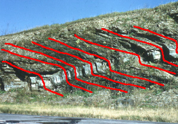
Mt. Ellen, like all of the peaks in the Henry Mountains, is an un-erupted volcano--a "granitic intrusion" that pushed up into the overlying sedimentary rock, but never broke the surface. Subsequent weathering has revealed a variety of geological features, from the granitic core to the sedimentary layers that the core pushed into. At some distance from the mountain, the strata are primarily horizontal. As you start to climb the mountain, you see the strata are at a slight angle. As you go higher, the strata are at a steeper angle. As you near the peak, and come closer to the granitic core, you find that the shale metamorphoses to slate, and the limestone to marble.
Not only is this a great example of the ability of slow, steady pressure to bend the strata (they don't fold and pop like YEC has said it is "obvious" they would do). It is also a wonderful example of heat metamorphosing rock. You can walk along it, and there it is.
There are also a couple of good volcanic necks outside of Grants, NM, that have been sliced by erosion of canyons, to produce cross-sections that you can see as you drive along on Interstate 40. There's the vertical basaltic neck itself, and to the right and left, visible gradations of the rock through which the basalt flowed upward. Near the neck, it is metamorphosed from the heat. Far from the neck, it is un-metamorphosed.
John S wrote: I think it’s a mistake to use local surface exposures (even very impressive ones like the Grand Canyon) to make generalizations about the entire rock record.
This is probably one of the most profound statements in this thread. Thanks, John. It gets at some of the questions I posed in
The Flood as Science, in which we ask just what the flood model predicts. While it may be possible to develop an idea based on one locale (say, the Grand Canyon), that idea is not supported by examination of other locales. Yet, the one-locale explanation is quite common in this debate.
My guess is that there is a difference in what different people consider "scientific" to be. To many, an explanation is "scientific" if it explains the specific phenomenon in question. That's enough to meet the criterion of "science." This is consistent with the Grand Canyon flood geology story, the polonium halo story, etc. What is missing is what other people include in "scientific" explanations: consistency with other observations from other places, and the ruling out of other alternative explanations.
One of the things that hasn't been discussed broadly is eolian deposits. I'd chosen the Chinle sandstone, which one can (or could) hike through when visiting White House Ruins. The Navajo is also good. With you link to modern eolian deposits at White Sands, showing how natural processes we can study today create this kind of sediment, I can't think of a way to wiggle out of the conclusion that these types of sandstone are, indeed, petrified dunes.
And--the petrified dunes are both overlain and underlain by shales and limestones! This seems like pretty clear evidence that there had to be
at least three time periods that must be accounted for by any flood model: the first batch of sedimentation in the flood, then a waterless period in which great dunes could form, and then
another period of underwater sedimentation.
This is very much like the finding of forest above forest above forest in coal mines. If the ancient forest was killed by the flood, which forest was it, and what killed and covered the others? There must have been many floods, not just one--and probably local ones, at that,
because that's what happens on earth extremely commonly.
Having said all of this, I will recall a bit of otseng's original post at the beginning of the thread, and comment on "uniformitarianism." This term does not mean that everything happens at a specific, linear rate, fully uniformly. It means that what happened long ago was pretty much what happens now. The term was invented to be a contrast to a giant catastrophe like a world-wide flood. At the time the term was invented, geologists knew about erosion, and sediment formation, etc, so it was easy to imagine that these were reasonably uniform processes. It doesn't take much brainpower to add to the idea of "normal processes," and include volcanic eruptions that bury everything nearby in ash (a catastrophe, all right, and certainly not "uniform," but still a "normal process"). It is easy to add local floods, mudslides, collapse of cliffs, wind-blown sand, or even meteor impacts. There's a lot of stuff that happens that is not uniform over the whole world, or uniform in time. "Uniformitarianism" doesn't really make sense any more (and has, therefore, largely been abandoned, in the same way as "gradualism" in reference to evolution).


