How can we trust the Bible if it's not inerrant?

Argue for and against Christianity

Moderator: Moderators

Post Reply
User avatar
otseng
Savant
Posts: 20520
Joined: Thu Jan 15, 2004 1:16 pm
Location: Atlanta, GA
Has thanked: 197 times
Been thanked: 337 times
Contact:

How can we trust the Bible if it's not inerrant?

Post #1

Post by otseng »

From the On the Bible being inerrant thread:
nobspeople wrote: Wed Sep 22, 2021 9:42 amHow can you trust something that's written about god that contradictory, contains errors and just plain wrong at times? Is there a logical way to do so, or do you just want it to be god's word so much that you overlook these things like happens so often through the history of christianity?
otseng wrote: Wed Sep 22, 2021 7:08 am The Bible can still be God's word, inspired, authoritative, and trustworthy without the need to believe in inerrancy.
For debate:
How can the Bible be considered authoritative and inspired without the need to believe in the doctrine of inerrancy?

While debating, do not simply state verses to say the Bible is inspired or trustworthy.

----------

Thread Milestones

TRANSPONDER
Savant
Posts: 8178
Joined: Thu Apr 29, 2021 8:05 am
Has thanked: 957 times
Been thanked: 3549 times

Re: How can we trust the Bible if it's not inerrant?

Post #401

Post by TRANSPONDER »

I had a check on the Rockies (note the Grand Canyon is in the plain so there shouldn't be continuous tilting.Indeed, it is remarkable that there is any) and while explaining a lot of the questions posed, it shows quite clearly the strata tilting one expects with new mountain -building including upthrust of basic rocks (basalt).


TRANSPONDER
Savant
Posts: 8178
Joined: Thu Apr 29, 2021 8:05 am
Has thanked: 957 times
Been thanked: 3549 times

Re: How can we trust the Bible if it's not inerrant?

Post #402

Post by TRANSPONDER »

A follow up - I can anticipate a rejoinder to the video:

"Well, clearly the sedimentary rocks were laid down by the Flood and God had the basalt pushed up to produce the mountains (with tilted strata) after the Flood (perhaps arguing that was what made the water appear to recede). In other words, SG but all done in a few months rather than millions of years.

The objection to that argument is folded rocks where the rocks look like they have been folded like layers of putty. This can happen- rocks can 'flow'under pressure - over a very, very long time. It can't be a few months or even years as the rocks would just shear.

So, again, this should be a feature of New'mountains.

Folds result from the slow deformation of rocks. This happens deep underground where the rocks are under pressure and temperatures are higher. Folded rocks are common in mountain ranges like the Alps, Himalayas and the Scottish Highlands.(wiki)

Alps and Himalayas a 'new'ranges (they are sharp and not greatly eroded) and I would predict that the Rockies and Andes also have examples of folded strata. But I haven't been able to verify that, yet.

User avatar
otseng
Savant
Posts: 20520
Joined: Thu Jan 15, 2004 1:16 pm
Location: Atlanta, GA
Has thanked: 197 times
Been thanked: 337 times
Contact:

Re: How can we trust the Bible if it's not inerrant?

Post #403

Post by otseng »

I will now present all the questions. SG proponents will answer the questions first and then I will present the FM and answer all the questions. And then we will conclude the flood discussion and get back to the main topic of this thread.

How did the sedimentary stratas form?
Where did the sediment come from to form the layers?
Why would layers be parallel?

If all the layers were formed under water, why is the majority of sedimentary strata now on land and there is practically none in the oceans?
If layers were all formed underwater and since its now above water, how did that happen? Did the land rise or did the sea level fall? How did that happen? Why did that happen after all the layers were formed?
If the sea level fell, how did that happen?
If the land rose, how was it able to rise perfectly for thousands of feet so that it maintained the parallel layers and be parallel to the horizon?

If erosion occurred in the strata, where did the sediments go?
Where do we see erosion that has caused flat erosion happening now so that it becomes parallel with the layer below it?
When we see water erosion happening now, do you expect the final result to be a flat strata, or more like a stream/river pattern?
What accounts for the sediment pattern off the coasts in the oceans?

Why is there geologic activity (erosion, tilting, folding) on a massive scale after all the layers were formed but practically none while they were being formed?
Why would massive geologic activity only occur after all the parallel layers have been deposited?
Do we see any canyon formation in the lower layers?
Why is there not an abundance of staggered faults and nonparallel layers and river formations in the strata?

How can one determine if an unconformity is due to lack of deposition or due to erosion?
Why or how can erosion in an unconformity result in a layer parallel to the one below it?
If erosion occurred, was the layer above sea level when it occurred?
If it was above sea level, how did it become above sea level?

How can the erosion pattern be explained in Monument valley and surrounding areas?
How many times has the Grand Canyon been lowered and raised to account for deposition and erosion (unconformities) in the layers?
Before the Grand Canyon started to be eroded by a river 6 million years ago, was the entire region just a flat area with the entire strata underneath it? Why has it been flat for over a billion years with no major river erosion (like what we see now) prior to 6 million years ago?
How can the angular unconformity be explained in the Grand Canyon?

User avatar
brunumb
Savant
Posts: 6002
Joined: Thu Nov 02, 2017 4:20 am
Location: Melbourne
Has thanked: 6627 times
Been thanked: 3222 times

Re: How can we trust the Bible if it's not inerrant?

Post #404

Post by brunumb »

otseng wrote: Thu Dec 09, 2021 8:58 am I will now present all the questions. SG proponents will answer the questions first and then I will present the FM and answer all the questions.
Sorry otseng, but that is an unrealistic expectation given the number of questions posed and the complexity of the task overall. I doubt that anyone here has the expertise required.

I guess that means we will not be seeing a point-form summary of how the biblical flood transformed the landscape and led to the geology we see in the world today. :(
George Orwell:: “The further a society drifts from the truth, the more it will hate those who speak it.”
Voltaire: "Those who can make you believe absurdities can make you commit atrocities."
Gender ideology is anti-science, anti truth.

TRANSPONDER
Savant
Posts: 8178
Joined: Thu Apr 29, 2021 8:05 am
Has thanked: 957 times
Been thanked: 3549 times

Re: How can we trust the Bible if it's not inerrant?

Post #405

Post by TRANSPONDER »

otseng wrote: Thu Dec 09, 2021 8:58 am I will now present all the questions. SG proponents will answer the questions first and then I will present the FM and answer all the questions. And then we will conclude the flood discussion and get back to the main topic of this thread.

How did the sedimentary stratas form?
Where did the sediment come from to form the layers?
Why would layers be parallel?

If all the layers were formed under water, why is the majority of sedimentary strata now on land and there is practically none in the oceans?
If layers were all formed underwater and since its now above water, how did that happen? Did the land rise or did the sea level fall? How did that happen? Why did that happen after all the layers were formed?
If the sea level fell, how did that happen?
If the land rose, how was it able to rise perfectly for thousands of feet so that it maintained the parallel layers and be parallel to the horizon?

If erosion occurred in the strata, where did the sediments go?
Where do we see erosion that has caused flat erosion happening now so that it becomes parallel with the layer below it?
When we see water erosion happening now, do you expect the final result to be a flat strata, or more like a stream/river pattern?
What accounts for the sediment pattern off the coasts in the oceans?

Why is there geologic activity (erosion, tilting, folding) on a massive scale after all the layers were formed but practically none while they were being formed?
Why would massive geologic activity only occur after all the parallel layers have been deposited?
Do we see any canyon formation in the lower layers?
Why is there not an abundance of staggered faults and nonparallel layers and river formations in the strata?

How can one determine if an unconformity is due to lack of deposition or due to erosion?
Why or how can erosion in an unconformity result in a layer parallel to the one below it?
If erosion occurred, was the layer above sea level when it occurred?
If it was above sea level, how did it become above sea level?

How can the erosion pattern be explained in Monument valley and surrounding areas?
How many times has the Grand Canyon been lowered and raised to account for deposition and erosion (unconformities) in the layers?
Before the Grand Canyon started to be eroded by a river 6 million years ago, was the entire region just a flat area with the entire strata underneath it? Why has it been flat for over a billion years with no major river erosion (like what we see now) prior to 6 million years ago?
How can the angular unconformity be explained in the Grand Canyon?

Otsemg...mate.... :o haven't we done all this? Hasn't the process of erosion why water and weather (laid down in parallel strata as why not?) the solidification of sedimentary rocks into hard metamorphic strata (requiring a Lot of time).

It is false I am sure, to argue that goelogical activity did not happen while layers were being formed and only after the strata had been deposited.Old mountains often show previous mountains revealed by the erosion of the newer ones. The geology was going on all the time. The raising of seabeds above present sea levels was explained in terms of subduct raising of levels with more mantle material from below. Seen especially where basalt pushes though existing strata. The lack of action on the plains (flat strata id because faulting and crumpling (mountains) happens at the edges of tectonic plates.

We do see buried river valleys below later strata. The obvious history of the grand canyon is igneous rocks, sedimentary rocks under ocean raised up, tilted, the strata of the unconformity scraped away (by the glaciers of snowball earth, I'd suppose), more strata laid flat would be flat (why not) and raised up above sea level (if it wasn't already) and the newer mountain ranges of the Rockies from which the river would flow across the plains and over a few millions of years cut down into the old layers.

Why when an area of mantle is pushe up why would a tectonic plat not maintain it's strata?It might bulge or tilt or fold at the edge or crack and slip.But the strata would still be there.
Now this is just going on what I saw about Grand Canyon geology. It is (with the final debunk of a Flood causing the Grand Canyon because the meanders had to have been millions of years in the making) enough that your restating of question that have largely been answered is not making you look good.

Monument valley? By natural erosion, of course. Weather or water. A global flood would do exactly the same, except it would have to do it in a year, not millions of years. Some eroded layers were clearly above sea if they contain land -fossils, but were below if water -fossils.Easy enough. The matter (not necessarily 'sediments' of erosion would go to lower levels if there is one, but would otherwise for a layer of different material over the one being eroded. Where dust the dust go when it build up on your carpet? On the carpet.

How can you claim there are no strata under water. Just because tourists can't photograph them in a park, doesn't mean there is no geology underwater.

I don't even know what you are asking here:

"How can one determine if an unconformity is due to lack of deposition or due to erosion?
Why or how can erosion in an unconformity result in a layer parallel to the one below it?"


Unconformity due to lack of deposition? Erosion in an unconformity parallel to the one below it? If it is tilted, the strata below would also have to be tilted. Even in a global flood. Why do you suggest it is some other way? Do you know and can you demonstrate this or are you just making up problems that don't exist?

TRANSPONDER
Savant
Posts: 8178
Joined: Thu Apr 29, 2021 8:05 am
Has thanked: 957 times
Been thanked: 3549 times

Re: How can we trust the Bible if it's not inerrant?

Post #406

Post by TRANSPONDER »

I'm not going to pretend I didn't cut and paste this, but the fact is that features like unconformities, raised up sea beds and folded strata in recent mountains ranges is rather a problem for a Flood than for deep time geology.

How does a global flood explain angular unconformities? These are where one set of layers of sediments have been extensively modified (e.g., tilted) and eroded before a second set of layers were deposited on top. They thus seem to require at least two periods of deposition (more, where there is more than one unconformity) with long periods of time in between to account for the deformation, erosion, and weathering observed.

How were mountains and valleys formed? Many very tall mountains are composed of sedimentary rocks. (The summit of Everest is composed of deep-marine limestone, with fossils of ocean-bottom dwelling crinoids [Gansser, 1964].) If these were formed during the Flood, how did they reach their present height, and when were the valleys between them eroded away? Keep in mind that many valleys were clearly carved by glacial erosion, which is a slow process.

How can a single flood be responsible for such extensively detailed layering? One formation in New Jersey is six kilometers thick. If we grant 400 days for this to settle, and ignore possible compaction since the Flood, we still have 15 meters of sediment settling per day. And yet despite this, the chemical properties of the rock are neatly layered, with great changes (e.g.) in percent carbonate occurring within a few centimeters in the vertical direction. How does such a neat sorting process occur in the violent context of a universal flood dropping 15 meters of sediment per day? How can you explain a thin layer of high carbonate sediment being deposited over an area of ten thousand square kilometers for some thirty minutes, followed by thirty minutes of low carbonate deposition, etc.? [Zimmer, 1992]


I know you have a policy otseng mate, of deferring answering any questions yourself and just coming up with an endless string of new ones, but really how can you claim that there is no under sea stratification? Since sea beds and strata have been raised up, I'd suppose the evidence is that strata (not yet raised up) is down there. How can you say and assume that there isn't?

TRANSPONDER
Savant
Posts: 8178
Joined: Thu Apr 29, 2021 8:05 am
Has thanked: 957 times
Been thanked: 3549 times

Re: How can we trust the Bible if it's not inerrant?

Post #407

Post by TRANSPONDER »

and more...

There's obviously much being made of the fact that an Unconformity can be caused by no rocks being laid down Or rocks being removed. And otseng asks 'which was it?' Research hasn't apparently showed which it was.So that doesn't make it evidence for a flood. I did incidentally detect that the tilt is in the layers all the way down to the basalt (which, in magma form,would have caused the tilt). The Unconformity also begins with the pre camnbrian which means the flood (if that is what it is supposed to be) was before pre -cambrian life even appeared.

Now I can hear it already 'The global unconformity was caused by the Flood sweeping away all the rocks and depositing all those strata filtered out, into layers with animals kinds also being filtered to look like a process of evolution, but was really because of how heavy they were or how well they could swim, which is odd when we find fish buried under dinosaurs. But just make anything up...'Well the flood brought down tons of soil burying the fish, and then the dinosaurs were washed in on top'. No doubt the agile smaller dinosaurs not being as fast,or light as the mammals like Elephants and Hippos which you will only find in upper levels'.

But if we have sea beds in the strata, how could the Flood have swept away all the strata? The strata with the sea beds especially those raised in mountains have to be the Flood - time sea bed and so the unconformity can't be the result of the Flood. So even if geology can't explain just why there is that missing bunch of rocks, it is not evidence for a Flood - if that was the idea.

TRANSPONDER
Savant
Posts: 8178
Joined: Thu Apr 29, 2021 8:05 am
Has thanked: 957 times
Been thanked: 3549 times

Re: How can we trust the Bible if it's not inerrant?

Post #408

Post by TRANSPONDER »

Coming clean. :D I'm no geological expert. I'm just an ordinary bod who feels in necessary to counter the dead weight of Religious misinformation being peddled by a well - funded religious industry. So all a Creationist has to do is copy and paste science -denial froma ton of Creationists sites and demand that the atheists explain every question, doubts and unknown. Even false ones like'no strata under sea bed'. I have to ask

otseng, demonstrate to me you claim that there is no strata under present sea beds. I don't know, because I haven'#t been able to find online results of undersea geology if any. But that surely means that otseng doesn'tknow either and is making a claimwithout foundation. I'm open to being disproved.

There's also this business of the 'great unconformity' which I'd never even heard of. :D I specialise in NT analysis as you -all will probably guess. And I'm no expert in geology. But one of the things I like about places like this is how much I learn digging out answers to Creationist questions.

And there's a crafty little wiggle. All a Creationist has to do is look up questions scientists can't answer and demand that atheist apologists answer it as, if they can't the Creationists must be right. Now I don' know whether research into whether the unconformity was caused by glaciation or rocks just not being laid down (1). But then this isn't evidence for a Flood (which I suppose is the idea) but an unexplained. Creationists so often work with this idea of pretending that unless 'Evolutionists' (like standard theory geologists ;) ) explain every single question that must disprove Evolution and leave Genesis as the correct story. No, it doesn't work like that. Unexplaineds are unexplaineds and since much geology Has been explained in terms that scuppers a year long Flood folded strata in mountains including sea -bed strata, standard geology is the default theory for problems, Not a Flood, and I think we have to understand that before we go on fielding more creationist questions, before we get to ask questions about the Flood - theory. Though really otseng chuim, you Should now explain how the Flood accounts for folded strata.

It remains only, dear chums, to apologise for horrendous misstypes. I do try to read through and check before I post, but sometimes I miss stuff or am too tired by posting in the small hours, drunk on cider and spaced out on pipe baccy to see it. Have a great weekend, satanic hellspawn and deluded Biblesuckers alike :dance: .

(1) I'd suppose glaciation has to be right as the global snowball was around that time and would account fer a global phenomenon of rocks of that period missing, rather than globally no rocks produced at that time. But I can't get confirmation and again I feel keenly the lack of an atheist think tank with a lot of experts, Talk origins being the nearest.

TRANSPONDER
Savant
Posts: 8178
Joined: Thu Apr 29, 2021 8:05 am
Has thanked: 957 times
Been thanked: 3549 times

Re: How can we trust the Bible if it's not inerrant?

Post #409

Post by TRANSPONDER »

brunumb wrote: Thu Dec 09, 2021 6:10 pm
otseng wrote: Thu Dec 09, 2021 8:58 am I will now present all the questions. SG proponents will answer the questions first and then I will present the FM and answer all the questions.
Sorry otseng, but that is an unrealistic expectation given the number of questions posed and the complexity of the task overall. I doubt that anyone here has the expertise required.

I guess that means we will not be seeing a point-form summary of how the biblical flood transformed the landscape and led to the geology we see in the world today. :(

I agree and frankly I don't think we should allow Otseng to make the rules and control the conversation, as he can just pelt us with Creationist Questions as in debates (though I see this as informal discussion, rather) we get a back and forth, and already I think we have a case that folded strata with water - laid strata in mountain -ranges is a question that could scupper the Flood and save us all a lot of time, so I think that otseng at least should address that one before he gets to toss any more atheist -stumpers at us. Fair is fair.

User avatar
otseng
Savant
Posts: 20520
Joined: Thu Jan 15, 2004 1:16 pm
Location: Atlanta, GA
Has thanked: 197 times
Been thanked: 337 times
Contact:

Flood Model Summary

Post #410

Post by otseng »

Given the photographic evidence of canyons, mountains, buttes, and mesas, I maintain we see a general pattern in the sedimentary rock strata that parallel layers were deposited (with relatively little evidence of any geologic activity) and then after the layers were formed we see massive geologic activity (erosion, faults, mountain building).

The simplest explanation and without the need of ad hoc explanations to account for lack of geologic activity in the layers is not much time passed during the deposition of the strata. That implies all the stratas around the world formed at the same time within a short period. And then after the stratas around the world were laid, major geologic activity occurred.

The question is then what is the mechanism for all of this to happen. I propose the Flood Model is the most likely scenario of what happened.

Here is what I've posted before for an overview of the FM:
otseng wrote: Sat Aug 04, 2007 10:38 am (The following post is collated from several posts in the Global Flood thread.)

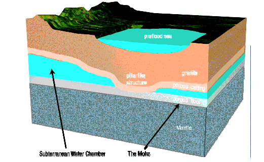
Let me start by describing the Earth before the Flood. The earth's atmosphere was very different than it is now. The temperature was more uniform throughout the earth and was mostly tropical. The entire world was covered by some sort of water canopy which allowed for a global tropical climate. It also did not rain. The earth had an abundance of large animals (dinosaurs) and large plants. The oceans did not exist as we know them now. However, there were seas that existed. The major mountain ranges did not exist and the mountains were smaller than what we have today. About half the water now in the oceans was once in interconnected chambers about 10 miles below the earth's surface. Europe, Asia, Africa, and the Americas were a connected land mass.

Here is a cross diagram of the earth before the Flood:
Image

We all know the idea that the land mass of Europe/Africa and the Americas were once one land mass. The commonly accepted idea is that plate tectonics broke up Pangaea over millions of years. There are many problems with this theory. But the most notable one is the existence of the 
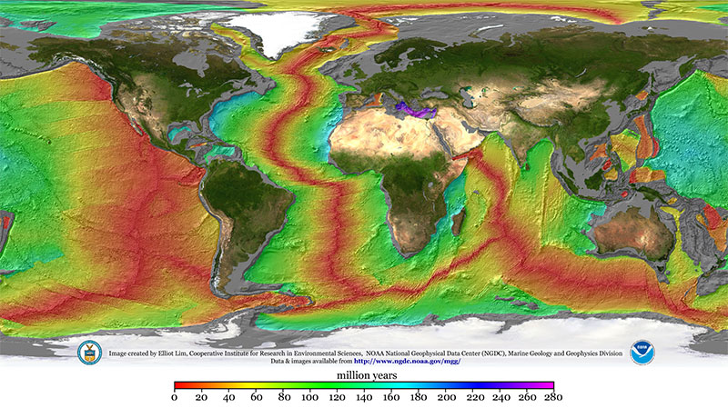
mid-Atlantic ridge. It is the longest mountain range in the entire world. It spans from Iceland to Antarctica (46,000 miles).

Image

Just looking at it, it is exactly halfway between Europe/Africa and Americas. And it looks like this is where the two split. Looking at this, it seems like the E/A and Americas were once joined at the mid-Atlantic ridge, then it got split apart.

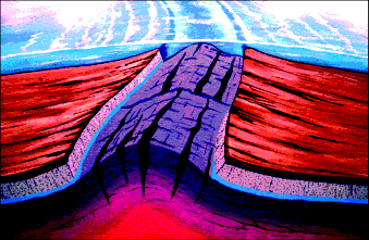
This split occured during the flood. During the initial stage of the flood (rupture phase), the crust split along where the mid-Atlantic ridge is. During the split, the subterranean water gushed out of the crack and eroded the the soil/rock on both sides of the crack. Meanwhile, as water was coming out, the two sides slid away from each other.

The two land masses were not once connected where the beaches are now, but they were connected where the continental shelves are. This explains the origin of the continental shelves.

Image

During the rupture phase as the subterranean water gushed out, the force of the water coming out eroded a lot of the soil/rocks and carried it high into the atmosphere and deposited it rapidly around the world. This destroyed the water canopy that had existed in the atmosphere. The pressure of the water gushing out would have formed the mid-Atlantic ridge.

The major land mountain ranges were formed as the water under the crust diminished. While there was water, the crust was free to move since water has a low friction coefficient. But once the water was gone, the crust hit the basalt underneath. With the large friction coefficient, the crust started to buckle. The crust had a huge lateral momentum as it was sliding away from the mid-Oceanic ridge. The momentum caused the crust to form the Rockies, Appalachians, Andes, Himalayas, etc.

As the water eroded the sides of the crust, it carried sediments and deposited it rapidly around the world. The entire world was covered with water and sediments at this point. Meanwhile, the crust was gradually settling as the water underneath decreased. As the land mountain ranges were forming and as the sediments in the water settled, the water receded into the oceans we have now and also froze in the North and South poles.

The massive amounts of sediments from the crust erosion formed practically all the rock stratas that we see today. So, instead of billions of years for it to form in the EM, it occurred within a year in the FM.

The rapid burial of the plants and animals caused the formation of most all the oil, coal, and fossils we find today.

There are 4 major phases of the flood: the rupture phase, the flood phase, the continental drift phase, and the recovery phase.

Image

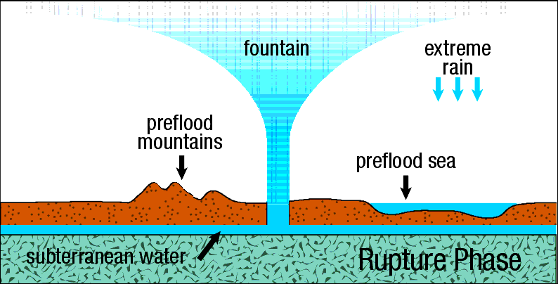
During the rupture phase, the crack on the crust formed that started at the mid-Oceanic ridge and traveled around the world. Water jettisoned from the underground chamber at the fissures into the atmosphere and eroded the sides of the cracks. I believe this phase occurred over days, perhaps weeks. Brown says this occurred in hours. I however think it must've been longer. I think the layers got deposited in stages to account for footprints in layers and also sequences of layers that could not be explained with a single deposit of sediments. Sorting of layers would take place between the stages where deposits were laid down. This entire process could not have happened in hours, but rather over many days.

Image

During the flood phase, sediments and water covered the entire earth. The surface topography was still relatively flat at this point. Brown says this phase lasted months long. I would say this probably last much shorter, in the range of days/weeks. My basis for this is that I don't agree with Brown on how the mid-Oceanic ridge got formed. Brown believes it was formed by the weight of the continents pressing down on the basalt and it eventually caused the mid-Oceanic ridge to form. I have a different hypothesis. I believe the oceanic ridges were caused by hydrodynamic forces as the water was ejected out of the earth. The pressure of the escaping water would cause the basalt to be forced upward by the water pressure forces and form the ridges. The formation of the ridges caused the flood to go into the next stage, the drift phase. Since hydrodynamic forces would have immediately formed the ridges, the flood phase could not last too long.

Image

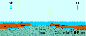
During the drift phase, as the mid-Oceanic ridge formed, the hydoplates slid down the ridge and the Americas and Eurasia/Africa moved away from each other. As the hydoplates moved, there was still some underground water under the hydroplates to allow for movement. But, when the water was gone, the hydroplates would stop moving when it hit the basalt underneath. The momentum of the moving hydoplates would cause the formation of the mountains. Brown believes this phase to have lasted 1 day, though I believed it lasted much longer, days/weeks.

Image

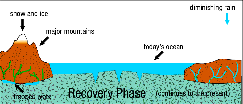
During the recovery phase, the water receded into the lower parts of the surface creating the oceans we have now. Canyons were created by water rapidly receding from the areas near mountains. The sea level was lower after all the water receded than compared to now. Over time, all the weight of the continents would cause the continents to gradually sink into the basalt underneath. This would cause the continents to be lowered, as well as push the sea floor up. This would explain land bridges in the past that are now covered by water today.
otseng wrote: Thu Dec 09, 2021 8:58 am I will now present all the questions. SG proponents will answer the questions first and then I will present the FM and answer all the questions. And then we will conclude the flood discussion and get back to the main topic of this thread.

How did the sedimentary stratas form?
As we all agreed, all the sedimentary stratas formed underwater.
Where did the sediment come from to form the layers?
The sediments came from the erosion of the continental plates during the rupture of the crust at the mid-oceanic ridges.
Why would layers be parallel?
Non-parallel layers would indicate there was tilting of the layers while the layers were being deposited. Since all the layers are parallel, it would indicate little time passed between the formation of each layer and there was no tectonic activity during the deposition of the layers.
Why is there not an abundance of staggered faults and nonparallel layers in the strata?
There was a small time span during the deposition of the layers and no tectonic activity such as faults or tilting could occur.
If all the layers were formed under water, why is the majority of sedimentary strata now on land and there is practically none in the oceans?
What accounts for the sediment pattern off the coasts in the oceans?
Here is map of ocean sediment thickness. For the sediments that are in the ocean, the majority is off the coastlines.

Image

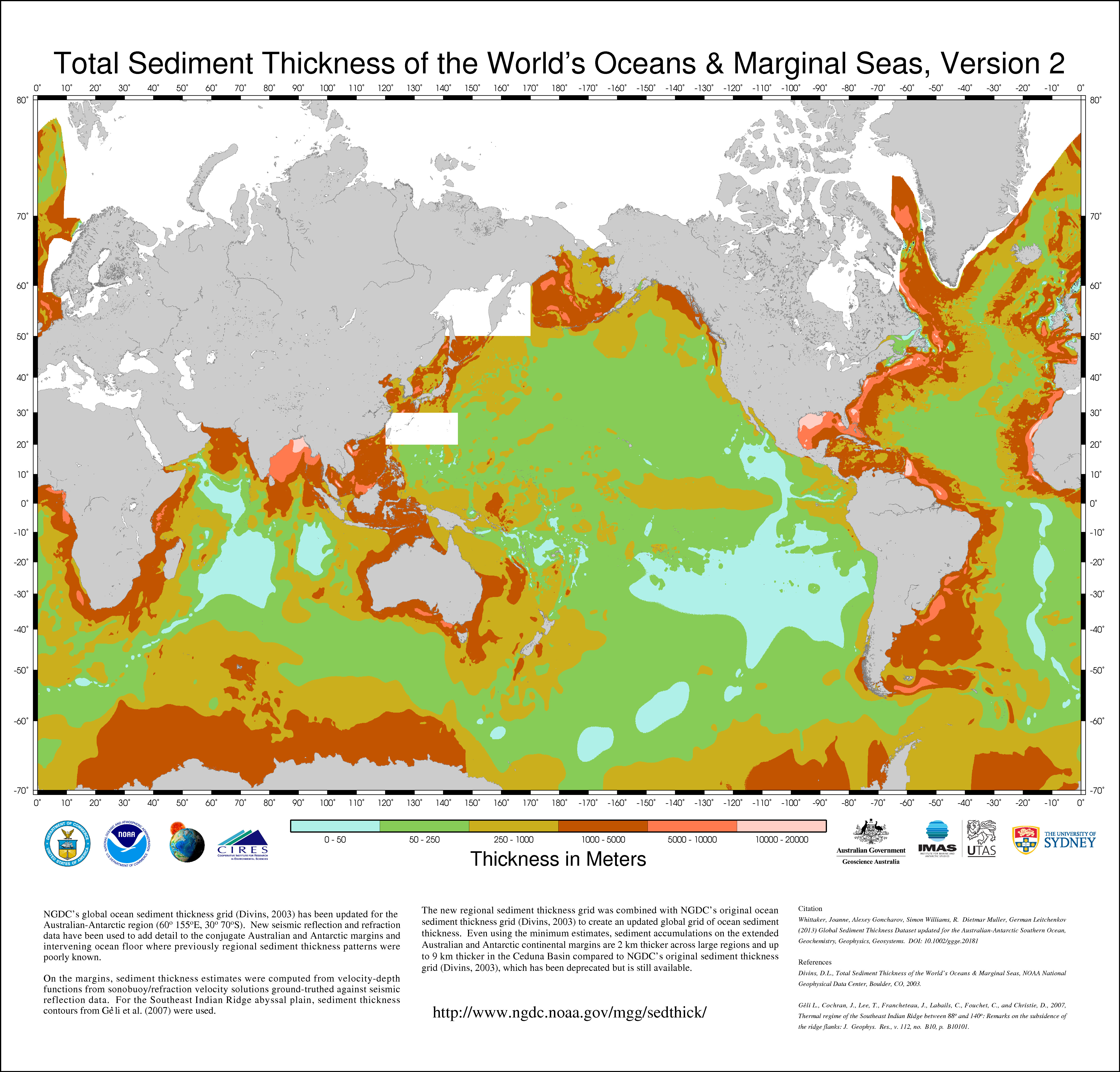
The sediments in the ocean is from the final water erosion from the continents during the recovery phase when the mountains were formed and flood water receded into the ocean.

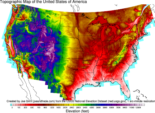
This final water erosion pattern is evident in a topographic map of the US and matches the sediments found in the ocean:

Image
If layers were all formed underwater and since its now above water, how did that happen? Did the land rise or did the sea level fall? How did that happen? Why did that happen after all the layers were formed?
If the sea level fell, how did that happen?
If the land rose, how was it able to rise perfectly for thousands of feet so that it maintained the parallel layers and be parallel to the horizon?
In the FM, the sea level fell due to mountain creation and formation of the oceans between the continental shelves.
Where do we see erosion that has caused flat erosion so that it becomes parallel with the layer below it?
When we see water erosion happening now, do you expect the final result to be a flat strata, or more like a stream/river pattern?
All erosion patterns in the FM are river-like erosion patterns. There are no flat erosions posited by the FM.
Why is there geologic activity (erosion, tilting, folding) on massive scale after all the layers were formed but practically none while they were being formed?
Layers were formed during the flood phase. It occurred on the order of days/weeks, not millions of years.
Why would massive geologic activity only occur after all the parallel layers have been deposited?
Massive geologic activity occurred during the drift and recovery phase.
How can one determine if an unconformity is due to lack of deposition or due to erosion?
Why or how can erosion in an unconformity result in a layer parallel to the one below it?
Unconformities only exist if deep time is assumed to be true.
How can the erosion pattern be explained in Monument valley and surrounding areas?
One thing interesting about the Monument valley area is it could not have been eroded by a river. What else then could have eroded this area? The mechanism is more like a giant bathtub full of water and loose mud at the bottom. And then the plug was pulled out. If you look at a topographic map of the area, the entire region is surrounded by mountains. But, there is one point where the water from the giant bathtub escaped. It is at the Grand Canyon. It was this escaped water from the giant flooded reservoir that carved out the Grand Canyon.
How can the angular unconformity be explained in the Grand Canyon?
The sedimentary layers are formed from rock being eroded at the mid-oceanic ridges. The tilted supergroup formation was formed by erosion of the Pacific ridge west of the American continent. After this strata was deposited, tectonic activity caused the layers to be tilted. Then the layers in the tonto group and above were formed by the continental crust eroded along the mid-Atlantic ridge.

Image

Post Reply